SWIFFT Seminar notes 23 April 2020
Sensing our environment
SWIFFT seminar notes are a summary of the seminar and not intended to be a definitive record of presentations made and issues discussed.
This SWIFFT seminar was conducted via Zoom with 297 online participants. SWIFFT wishes to acknowledge support from the Department of Environment, Land, Water and Planning, Victoria in organising the seminar. We thank speakers for their time and delivery of presentations. Thanks also to Michelle Butler who acknowledged traditional owners and chaired the session from Ballarat.
Key points summary
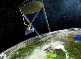
Satellite soil moisture data assimilation
- Data assimilation is an important means of improving the accuracy of soil moisture forecasting.
- Soil moisture is critical for forecasting vegetation conditions and droughts.
- Improvements from soil moisture data assimilation provide longer range forecasts.
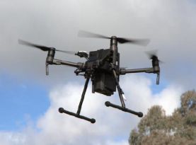
Wildlife Drones
- Up to 40 tagged animals can be tracked simultaneously.
- There is very little impact on animal behaviour. It is one of the least invasive ways of monitoring animals.
-
Most tags can be picked up 600m to 1 km from the drone. Larger animals with more powerful tags can extend the signal range for up to 4 km.
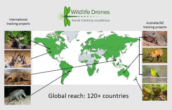
- ‘Wildlife Drones’ has expanded with projects in 120 countries.
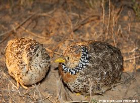
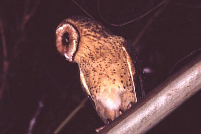
Acoustic monitoring - Plains-wanderer
- Acoustic monitoring is valuable tool in identifying Plains-wanderer habitat and occupancy.
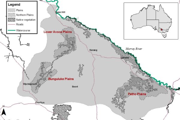
- Victoria’s Northern Plains Grasslands (Patho Plains and Lower Avoca Plains) are key areas of habitat for the Plains-wanderer.
- Biomass management is vital for survival of the Plains-wander.
Autonomous Sensing and Mobile Systems
- CSIRO are developing a range of robots for various monitoring applications.
- Automation is beneficial for continuous monitoring of natural resources and animals providing more accurate field assessments.
- Autonomous systems can be effective in collecting data to establish patterns, trends and behaviour of animals.
The Australian Acoustic Observatory
- Acoustic monitoring has many advantages over repetitive on-site field work, once set up the passive acoustic sensors do not require repetitive visits as they can stay in the field for months on end.
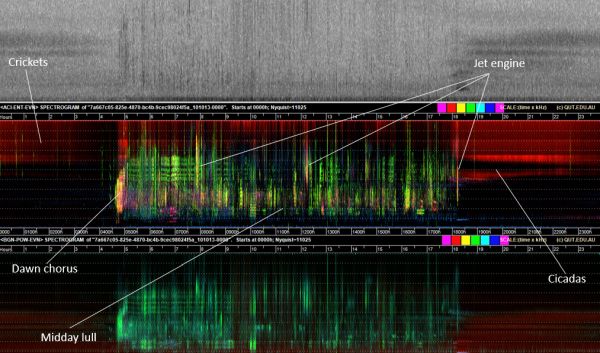
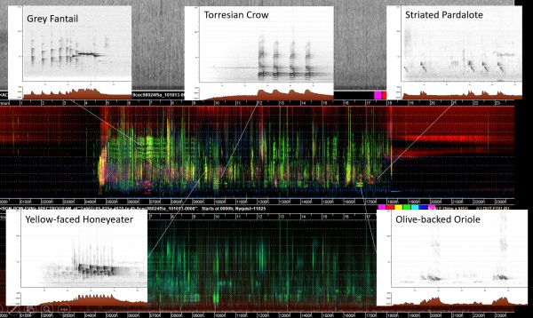
- False colour spectrograms are used to display acoustic data categorised by colour coded acoustic indices.
- As well as being able to see the broader harmonics of a system it is possible to identify the presence of selected species.
- At present there are 400 sensors at 100 sites stratified by region across Australia. The sensors are continuously recording 24 hours a day 7 days a week.
List of topics and speakers
Forecasting drought impacts through Satellite soil moisture data assimilation - Siyuan Tian, Centre for Water and Landscape Dynamics, Australian National University
Wildlife Drones – from Parrots to Payloads - Dr Debbie Saunders - Wildlife Drones
Plains-wanderer - new technology to help find a cryptic bird - Bec James, Department of Environment, Land, Water & Planning, Lodden Mallee
Stealth robots – spying on wildlife just got real - Ashley Tews, Senior Research Scientist, CSIRO
Taking the pulse of a continent: the Australian Acoustic Observatory - David Watson, Charles Sturt University - Australian Acoustic Observatory
Forecasting drought impacts through satellite soil moisture data assimilation
Siyuan Tian, Centre for Water and landscape Dynamics, Australian National University
Siyuan introduced her presentation by discussing how soil moisture information from satellite data simulation can be used to forecast vegetation condition and drought impacts. Although the volume of soil moisture is small compared to other components of the hydrological cycle it is a key variable in controlling the water and heat energy exchange between the land surface and the atmosphere.
Soil moisture is critical in climate and weather predictions as well as cloud view forecast and irrigation planning.
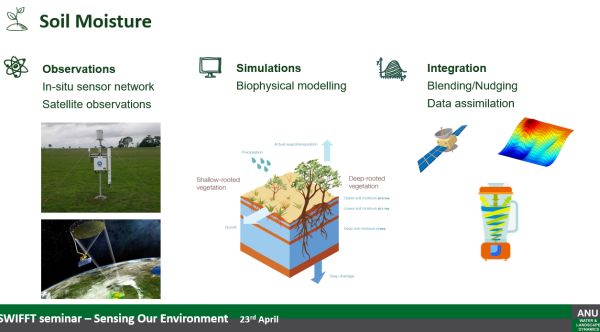
Soil moisture data is collected from small scale ground stations and satellite missions which provide spatial and temporal variance of soil moisture at a global scale.
Data assimilation
As observations and model predictions are imperfect, data assimilation is used to gain a more accurate result. Data assimilation uses current and past observations combined with modelled data to produce soil moisture forecasts.
Siyuan showed several maps of Australia which demonstrated the benefits of data assimilation, soil moisture mapping before and after assimilation modelling. After data assimilation the maps provided improved spatial and temporal information.
Forecasting vegetation conditions
Siyuan spoke about the Water Balance Model which is used to simulate water resources from surface water, soil water and combined groundwater systems. Three types of satellite water observations are used in modelling.
- Soil Moisture and Ocean Salinity (SMOS) – daily, surface soil moisture to 50 km resolution
- Gravity Recovery and Climate Experiment (GRACE) – monthly, total water storage change with a 300 km resolution
- Moderate Resolution Imaging Spectroradiometer (MODIS) - 8-day composites of surface water extent.
Assimilation of data from the three satellites provides improved estimates of soil water availability. Statistical relationship between the observed surface greenness and the soil water storage at monthly scale is used to forecast future vegetation density and condition expressed as Normalized Difference Vegetation Index (NDVI).
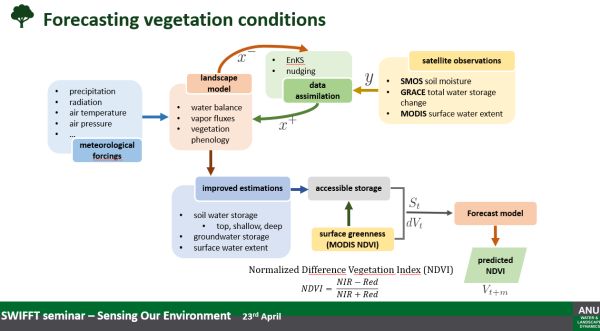
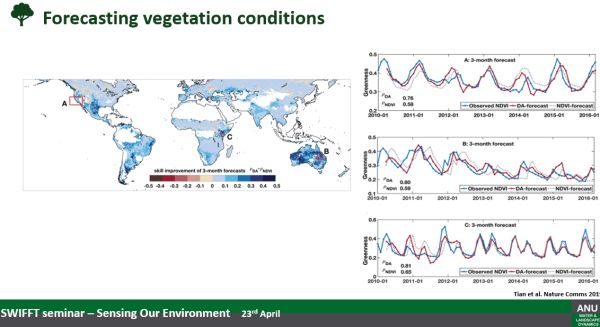
Information on soil water content at different depths is used for different vegetation types at different locations to provide forecasts for 2-3 months in advance across global drylands. For grasslands and cropland areas the forecast is limited to approximately one month in advance.
Siyuan pointed out differences in DVI over three locations (charts right) comparing; observed soil moisture (red) and climatology forecasts (blue) and NDVI forecasts (grey).
Research paper:
Tian, S., Renzullo, L. J., Van Dijk, A. I. J. M., Tregoning, P., & Walker, J. P. (2019). Global joint assimilation of GRACE and SMOS for improved estimation of root-zone soil moisture and vegetation response. Hydrology and Earth System Sciences, 23(2), 1067-1081. https://doi.org/10.5194/hess-23-1067-2019
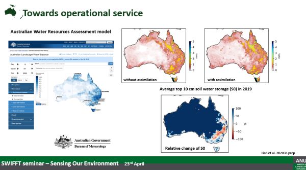
Australian Water Resources Assessment model
Siyuan has been working in collaboration with the Australian Bureau of Meteorology to build data assimilation capability in the Australian Water Resources Assessment model. It is hoped the system will be on-line by the end of 2020 to provide moisture analysis using data assimilation which provides improved soil moisture forecasts.
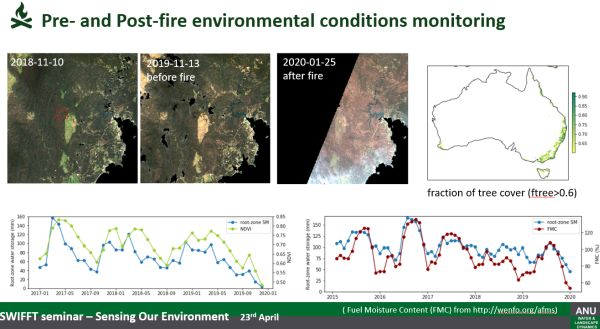
Soil moisture conditions before the 2019/20 bushfires
Siyuan spoke about the decline in soil moisture prior to the 2019/20 bushfires. Analysis of Landsat Imagery showed the area to be under extremely dry conditions before the fires which provided conditions for the fires to spread quickly. A time series of the root zone soil moisture from the data assimilation system and the NDVI demonstrates a significant change since 2017. Root zone soil moisture and fuel moisture content in forests showed a decline in moisture during 2019/20.
Summary
Variation in root zone water can impact on growth and condition of grazing land, crops and native vegetation. The vegetation condition influences the fire risk and soil health. Being able to understand soil moisture condition can assist in being better prepared for possible impacts.
Siyuan thanked collaborators from the Centre for Water and Landscape Dynamics - Australian National University, Water Resources Modelling Unit Bureau of Meteorology and Geoscience Australia.
Available Data:
Global Root-zone moisture Analysis and Forecast System (GRAFS): for near real-time 0.1deg soil moisture (note; large files in this dataset).
http://dapds00.nci.org.au/thredds/catalog/ub8/global/GRAFS/ http://dapds00.nci.org.au/thredds/catalog/ub8/global/W3/v2/0_05d/catalog.html
Landsat-based burn severity and burn scar mapping (BurnCube): for temporal land cover change analysis
https://github.com/GeoscienceAustralia/burn-mapping
Australian Landscape Water Balance
http://www.bom.gov.au/water/landscape/#/sm/Actual/day/-28.4/130.4/3/Point////2020/4/23/
Key points from questions
- Siyuan’s work has been applied more to a global soil moisture forecasts rather than a local scale.
- There is a relationship between the root zone soil moisture deficiency, fuel moisture content and bushfire risk. Work is underway to predict soil moisture content to produce fire risk forecasts.
- Soil moisture observations are assimilated into the top soil layers from the Australian Water Resources Assessment model together with evapotranspiration but this difficult because evapotranspiration is highly variable.
- The current modelling does not include permafrost areas or CO2 data for modelling climate change.
Back to list of topics and speakers
Wildlife Drones – from Parrots to Payloads
Dr Debbie Saunders - Wildlife Drones
Debbie introduced her presentation by discussing previous research on determining the wintering habitat of Swift Parrots, a species that proved very difficult to monitor, particularly their location and movements. With the early development of drone technologies Debbie began trialling the use of drones to locate tagged birds. Initially the focus was on Swift Parrots but it was found attaching tags to this species came with risks so the trials moved to tracking Noisy Minors in woodlands.
Avanced tracking using drones
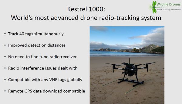
In recent years, drone technology has increased where it is now possible to undertake longer flights, with more tracking capability. Up to 40 tagged animals can be tracked simultaneously, these can be on the same species or multiple species. Drones can now detect tags up to 4 km from the drone which enables large areas to be monitored.
Worldwide expansion
Debbie spoke about the advances in drone tracking technology which has led to increased interest in tracking animals from many parts of the world. ‘Wildlife Drones’ has expanded with projects in 120 countries. Some of the projects are in remote areas, the advantage with drone technology is the ability to have real time tracking, particularly when used in conjunction with satellite tracking.
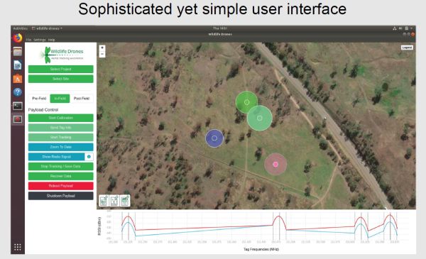
How it works
- Tag the animals you’d like to track with the VHF radio-tags of your choice.
- Attach Kestrel 1000 to your drone or Hire our pilot & drone
- When the drone is flying, the system will detect all tag signals within range at the same time
- The data is sent to the base station laptop and analysed and mapped in real time
Examples of successful projects
Debbie discussed several projects, in particular the tracking of Swift Parrots which has now been possible due to the use of much smaller temporary tags, combined with the new generation drones. The has enabled the location of Swift Parrot roost sites and identify critical areas of habitat.
Other examples of successful radio-tracking projects include;
- Radio tracking of Hair Wallabies on Dirk Hartog Island in Western Australia (remote location, species normally difficult to find).
- Radio tracking released Pangolins in Vietnam (dense understory, sometimes under cover and normally hard to find).
- Radio tracking Kapo in New Zealand (very difficult rocky landscape normally impossible for ground location).
Contact
Dr Debbie Saunders, CEO, Conservation Ecologist & Chief Remote Pilot, 0487 902 204
Wildlife Drones stories on YouTube
Key points from questions
- Some testing of tags has been carried out on bats with detection distances of 400-600 metres.
- Drones have been very effective in identifying critical habitat for Swift Parrots, many of the areas are much smaller than previously thought. This is very important for protecting critical habitat on private land.
- Animal ethics issues are reduced with ‘Wildlife Drones’ because the aim is not to fly over an animal but rather at a distance from the animal around the outskirts of the area. Used correctly there is very little impact on animal behaviour. It is one of the least invasive ways of monitoring animals.
- Monitoring marine mammals has not been undertaken at this stage but tracking sea turtles is possible although it has been found the salt water significantly reduces the signal.
- Freshwater does not trap the signal so monitoring freshwater fish and freshwater turtles in the top 1-2 metres is possible.
- Tracking signal range depends on the species being tracked and the size of the tag. Most tags can be picked up 600 m to 1 km from the drone. Larger animals with more powerful tags can extend the signal range for up to 4 km.
- The Swift Parrot work has mainly been in NSW. Some work is being developed to monitor in the breeding areas in Tasmania.
- Flight regulations in Australia mean the drone must fly below 120 metres and can only be flown in line of sight, but because the drone can pick up signals some distance away you can cover quite a large area. Extended line of sight can be managed by having an additional observer at a further point away.
- Flight time tends to be around 20 min. however, in that time it is possible to cover a very large area and track up to 40 animals.
Back to list of topics and speakers
Plains-wanderer - new technology to help find a cryptic bird
Bec James, Department of Environment, Land, Water & Planning, Lodden Mallee
Northern Plains Grasslands
The Northern Plains Grasslands in Victoria are a key habitat of the Plains Wanderer. The grasslands are recognised as being threatened and one of the most poorly reserved ecosystems in Victoria and Australia with only about 3.8% remaining.
Since European settlement about 95% of the Northern Plains Grasslands have been lost to agricultural development. Cultivation, both legal and illegal is considered the biggest threat to the grasslands across the plains. Another threat is either overabundance or underabundance of biomass which impacts on threatened species such as Hooded scaly-foot, Spiny-rice flower and Plains-wanderer.
Plains-wanderer
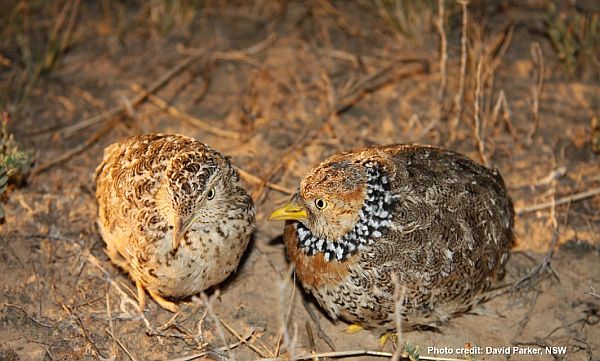
The Plains-wanderer is an iconic species native to Australia which occurs in Queensland, New South Wales, Victoria and South Australia. In 2015, it was listed as critically endangered under the national Environment Protection and Biodiversity Conservation Act 1999 (EPBC Act). It is also listed under the Victorian Flora and Fauna Guarantee Act 1975 (FFG Act). There are less than 1000 birds known to be left in the wild. The two remaining strongholds are northern plains in Victoria and the Riverina area in NSW.
In 2018, the Zoological Society of London listed Plains-wanderers as number #1 of Evolutionarily Distinct and Globally Endangered (EDGE) species.
Conservation of the Plains-wanderer
Habitat management is critical for the survival of this species. Survival is dependent on a specific mix of grasses, herbs and forbs. The Plains-wanderer tends to move around the grasslands looking for optimum habitat which makes biomass management a key for their survival.
Biodiversity On-ground Action – Icon species - Plains-wanderer project
This project is undertaken as part of the National Recovery Plan. Funding of the project is through the Department of Environment, Land, Water and Planning (DELWP) Biodiversity On-Ground Action Grants for Icon Species. It will assist the Victorian Plains-wanderer Operations Team to undertake surveys to determine where suitable and occupied habitat for Plains-wanderers across the Northern Plains in Victoria occurs.
DELWP’s Lodden Mallee Natural Environments Team leads the project in collaboration with Parks Victoria, Trust for Nature, Northern Plains Conservation Management Network (CMN), North Central CMA. It is a 4-year project sunsetting in June 2020.
Acoustic monitoring – Plains-wanderer
Song meters have been used to locate Plains-wanders in the landscape. It is the first time this type of technology has been used for finding Plains-wanderers. David Baker-Gabb has been contracted to provide advice, establish song meters in the field and liaise with landholders. Sixty song meters have been deployed across the survey area. Ten song meters were purchased by the Northern Plains CMN which is primarily a community group. About 55 song meters have been set up as permanent sites with 5 being used for temporary exploration.

Data collection
Each song meter has an SD card which stores data. They are collected about every 6 months and the data analysed using specially developed Plains-wanderer recognition software. The calls picked up by the software are double checked manually by the team.
Results
- In spring/summer 2017-18, adult female Plains-wanderers were recorded by 19 (50%) of 38 operational song meters.
- Over autumn/winter 2018, 14 (52%) of 27 operational song meters recorded Plains-wanderer calls.
- In spring/summer 2018-19, Plains-wanderers were recorded calling on 25 (50%) of 50 song meters at permanent monitoring sites on the Patho and Lower Avoca Plains.
- In spring/summer 2019 Plains-wanders were calling on 37 (68%) of 54 of the operating song meters.
Early indications are that there is some movement beyond the Patho Plains into the Lower Avoca Plains which could indicate an expansion in both numbers of birds and range. This aligns with more emphasis on ensuring grassland habitat is better managed to reduce biomass on areas of Public Land in the area.
Bec emphasised there has been a great deal of community and conservation management awareness and effort put into improving biomass management for the Plains-wanderer.
Overall, acoustic monitoring is a valuable tool in identifying where the species occurs and habitat condition which can assist in directing management efforts to priority areas.
Information gained from the song meter project has been shared with intestate partners which has enabled them to deploy the use of song meters in other areas.
Team effort
Bec pointed out the fact that the Acoustic Monitoring project is one part of a much larger effort to ensure the Plains-wanderer survives and prospers into the future.
Key points from questions
- The use of song meters has proven to be very effective but dependant on having the software to analyse the many hours of data. Simply deploying song meters for other species projects without having appropriate software is not advised.
- Cages have been used to protect song meters in paddocks where grazing occurs. Cages are not thought to attract raptors.
- Analysis of song meter data focuses on Plains-wanderer and no other species.
- Placement of song meters is based on selecting the most probable areas of habitat, not too much biomass nor too little.
Back to list of topics and speakers
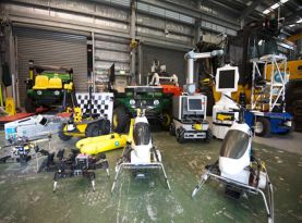
Stealth robots – spying on wildlife just got real
Ashley Tews, Senior Research Scientist, CSIRO
Ash introduced his presentation by talking about his work which involves developing robotics and automation to aid species conservation projects. He is working towards helping researchers get the technology into the field so they do not have to spend countless hours collecting data or servicing equipment in the field but rather use automation and robotics to perform tasks.
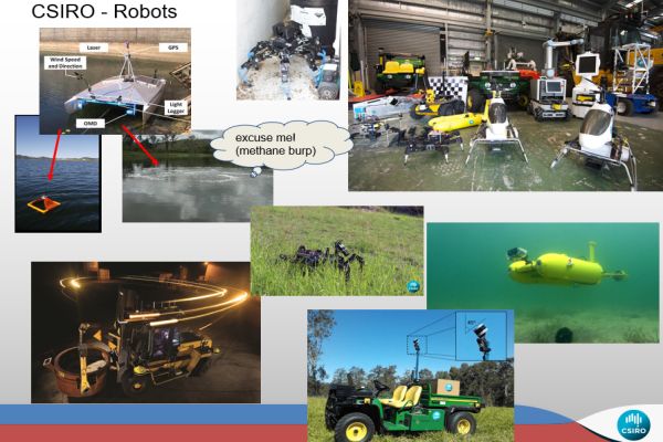
Examples of autonomous robotics:
- Long-term Autonomous Underwater Glider – operating for an 8-month trip across the Pacific Ocean collecting environmental data
- Autonomous tree planter
- Long Term Environmental Monitoring with the about 4,000 Argo Sensors which have a 4 year lifecycle and are located across the world’s oceans collecting data on sea temperate, currents and salinity.
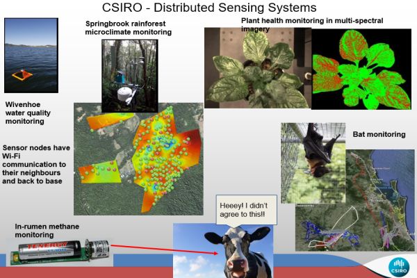
Applications of Autonomous Sensing and Mobile Systems
With an increase in the type of devices available it means there is more scope to use and rely on new technologies coupled with machine learning. Uses include:
- animal monitoring - in-rumen, eartags, collars and leg tags (bats, cows, pigs, koalas, water buffalo, etc.)
- environment monitoring - intelligent buoys, terrestrial sensors
- wildlife detection - intelligent camera traps, radio tomography
Robotics
- Pest control – plants, bugs? Animals (land, air bats, water fish)
- Biosecurity control (pigs, hosts) - autonomous mobile deterrents, RapidAim
- plants - weed detection and control, crop health monitoring and yield estimation, canopy density
Automation
- data accumulation and reasoning -> turn data to information for human use
- wildlife survey – visual, acoustic, thermal, spectral – static and mobile sensors (air/gnd)
- intelligent situation assessment in-field -> e.g. pest deterrent strategies (VPDaD)
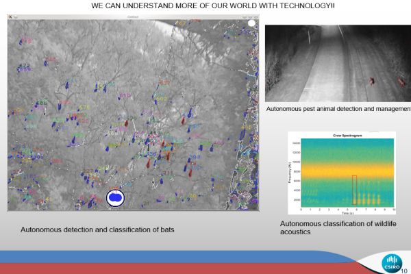
Real-world applications
- In-field analysis by image & environment sensing – upload to cloud/database – results immediately (AI classification)
- Auto-notification of events, anomalies, incursions, threats
- Robots – can augment or replace human assessments, environment monitoring, mapping, health, and act on the environment as humans would. Can be a field companion (i.e. another tool in the toolbox) e.g. autonomous control of Crown of Thorns starfish on the Barrier Reef.
- Machine Learning -> applicable to a wide range of tasks onboard robots or offline on data in the cloud –> learning in situ
- Smart camera traps with longer detection range and coordinated geo-ref tracking – distributed sensing to get global pseudo-view examples
Image sensing systems
Ash spoke about a range of robots developed by CSIRO for various applications. He also mentioned technologies using Lidar imaging attached to drones which can provide 3D mapping of confined spaces such as cave systems.
Vertebrate Pest Detect and Deter Project
This is the project which Ash is currently working on. His group are conducting R&D into autonomous, intelligent technology to aid land and invasive pest managers in receiving online and real-time wildlife activity information from the in-field systems. To-date, projects have been conducted in far North Queensland; Mahogany glider Recovery Team, Cassowary Recovery Team and Leadbeater’s Tree Kangaroo. Overseas projects include; Elephants - Central Africa, Sumatra, Mamirauá Reserve, Amazonas.
Summary
Automation is beneficial for continuous monitoring of natural resources and animals providing more accurate field assessments. Benefits of automation:
- in-field classification of animals, plants, water quality
- intelligent assessment of the environment and wildlife
- removes tedium from environment analysis
- only records significant/anomalous events
- capable of in-field decisions and notifies users if required
Further applications
- Canopy assessment
- Wildlife survey – visual, acoustic, thermal, spectral – static and mobile sensors (air/ground)
- Pest control – plants, bugs, animals (land, air, water) – autonomous IPM??
- Global knowledge base of information - people + autonomous systems
- Biosecurity control and management - e.g. pigs, bats, feral animals sharing resources with domestic animals
Contact
Ash Tews, Autonomous Systems Laboratory, CSIRO, Pullenvale, Queensland
Ash Tews e-mail Ph. +07-3327-4034
https://research.csiro.au/robotics/
https://blog.csiro.au/stealth-robots-spying-on-wildlife-just-got-real/
Due to time constrains questions were answered via Zoom text.
Back to list of topics and speakers
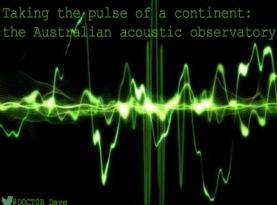
Taking the pulse of a continent: the Australian Acoustic Observatory
David Watson, Charles Sturt University - Australian Acoustic Observatory
Ecosystem soundscape analysis
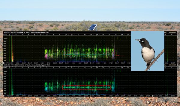
Dave spoke about the diversity of vocalisation calls from animals in the wild and how it is possible to determine what species are present at a location and the health of the ecosystem. Many of the calls are quite distinctive, they are displayed as a sonogram which can be used to identify particular species. Dave explained the project he is working on is not so much about individual species but more about whole of ecosystem soundscape analysis.
Example; Acoustic monitoring for tree identification
Dave spoke about the example of research carried out to identify species of trees in a tropical rainforest by recording sound; the subtle sounds of wind moving leaves and rain falling on different shaped leaves combined with influences from the architecture of the canopy all combine to be able to make it possible to identify species of trees.
Advantages of acoustic monitoring
Acoustic monitoring has many advantages over repetitive on-site field work, once set up the passive acoustic sensors do not require repetitive visits as they can stay in the field for months on end. There is less disturbance in fragile areas and to sensitive species. They also enable the collection of a log which spans long time frames.
Project team
Dave emphasised the team approach in driving the project forward.
Extent of project
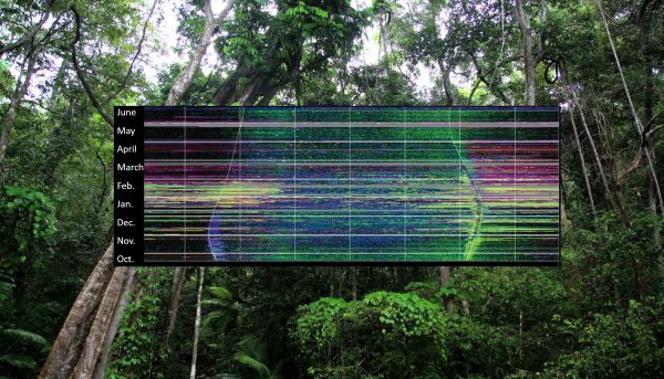
At present there are 400 sensors at 100 sites stratified by region. Each site has 4 sensors placed along a gradient of productivity e.g. 2 sensors at wetter more productive sites and 2 at drier less productive sites. Multiple sensors are used in case one of the sensors becomes unfunctional.
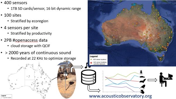
The size of the data set is extraordinary, it is anticipated that in 10 years the amount of data will be as large as the entire internet 10 years ago.
Dave stressed that many of things the team is wanting to do with the data is currently not doable. Australia is a large continent to cover, there is simply not enough resources in terms of sensing infrastructure and people to collect the data. Dave felt it is important to start collecting as much data as possible now and archive it so it can be used for studies into the future, particularly providing long-term comparability at both local and continental scale.
Case study of Pied Honeyeater in Stuart National Park
The Pied Honeyeater is a very difficult bird to study given it inhabits large areas of the arid zone and is very nomadic, appearing in some areas occasionally then moving away to new areas. Dave spoke about a study which used 14 years of continuous records to display ribbon plots which only took 17 hours to analyse. This is an incredibly efficient approach to determine the presence or absence of the honeyeater.
A further study looked at times of greenness in the landscape, particularly when Eremophila plants were flowering. It was found that after rainfall events Pied Honeyeater call rates went up which helps identify breeding areas.
Acoustic data for environmental monitoring
Dave spoke about the value of long-term monitoring for measuring climate change (rainfall and lightning events), particularly in remote areas of Australia. The sensors can also pick up seismic events.
Key points from questions
- Wind can be problematic for acoustic monitoring, particularly in arid areas.
- Identification of birds with several different calls can be difficult but is being worked on through computer learning. Frogs and bats have much lower vocal versatility which enables higher accuracy.
- Open access of data provides more scope for building on other applications which involve acoustic monitoring.