SWIFFT Seminar notes 26 October 2023
Surveys and Monitoring
SWIFFT seminar notes are a summary of the seminar and not intended to be a definitive record of presentations made and issues discussed.
This SWIFFT seminar was conducted online with 206 participants via Microsoft Teams. SWIFFT wishes to acknowledge support from the Department of Energy, Environment and Climate Action (DEECA), Victoria in organising the seminar and thank speakers for their time and delivery of presentations. Also, thanks to Michelle Butler who chaired the session from Ballarat and acknowledged Traditional owners, Elder’s past and present on the lands covered by the meeting.
This Seminar highlights some of the new technologies which are being used to improve the efficiency and effectiveness of survey and monitoring programs.
Key points summary
Agriculture Victoria Invasive Marine Species Port Surveillance Program
- Marine pests are a threat to Victoria’s marine environment, they can be transported by vessels through biofouling or ballast water.
- Over 4,000 vessels enter Victoria annually at the Ports of Portland, Geelong, Melbourne and Hastings.
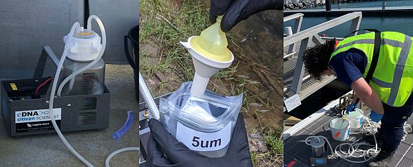
- All organisms leave fragments of their DNA in the environment; by extracting the environmental DNA from a sample the Invasive Marine Pest Commercial Ports Surveillance Program can determine the presence of marine pests without having to observe or capture the species.
- In Partnership with the port authorities and berth managers at the four major Victorian commercial ports, Agriculture Victoria has established a surveillance approach utilizing settlement arrays and water sampling to capture eDNA and identify marine pest species.
Edge AI cameras now dramatically improve monitoring capacity of Felixers
- Feral cats are the main threat to Australia’s fauna killing an estimates 1.4 billion native animals per year.
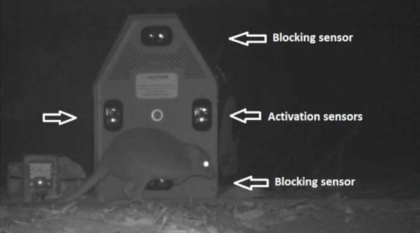
- The Felixer is a device that is designed to take advantage of the cat’s natural behaviour in grooming so that when a poison gel is fired onto the cat it will ingest the poison as it grooms itself, something that other native species and dogs don’t do.
- The Felixer is fitted with a Bluetooth antenna, GPS, EDGE AI camera and LiDAR sensors. With artificial intelligence and machine learning the cameras can become extremely reliable in differentiating between species which has enabled false targeting of species to be eliminated.
- Felixers are not only used as feral cat control but they are proving effective in monitoring / surveying wildlife.
- Cats fitted with a Bluetooth device could be part of a registration program.
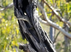
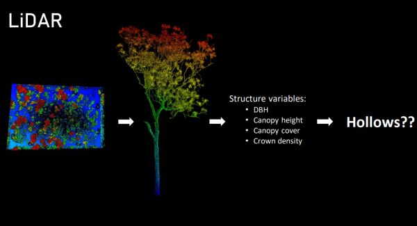
Hollows and how to find them
- Tree hollows are a critical habitat for many native fauna. There is a need to know more about the factors which influence the formation and abundance of hollows.
- The most common method for finding and counting tree hollows is from the ground looking up using binoculars but new technologies provide far more efficient an accurate means of determining the number of tree hollows.
- Drones can be used to find hollows that would be otherwise not visible from the ground e.g., vertical hollows. Drones can also determine if hollows are deep enough or blocked up.
- Sonic tomography is used to determine the internal structure of trees and can be used to estimate the extent of hollowness.
- LiDAR enables the remote sensing of vegetation structure and individual trees in the landscape, and can aid the ability to estimate hollow abundance.
- Data collect apps are used to streamline data collection and entry.
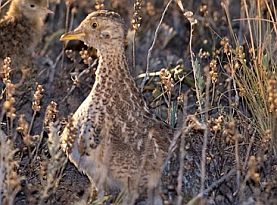
Using bioacoustics to monitor landscape-scale population dynamics of the critically endangered Plains-wanderer
- The Plains Wanderer is Critically endangered at a State and Federal level. It is the sole member of the Pedionomidae family, the only surviving species in a genetic line dating back 200 million years ago.
- It is estimated that only about 2,000 Plains Wanders remain in the wild today.
- Habitat loss which has occurred since European settlement is a major threat, resulting in loss of native grasslands and conversion to agriculture. Less than 1% of native grasslands still remains in Victoria.
- Cats and foxes are significant threats to the Plains Wanderer.
- The Plains Wanderer monitoring project currently uses 60 song meter recorders across the grasslands of northern Victoria. Song meters provide a recording of calls from which the Plains Wanderer can be identified.
List of speakers and topics
- Agriculture Victoria Invasive Marine Species Port Surveillance Program - Ryan Cooke - Agriculture Victoria
- Edge AI cameras now dramatically improve monitoring capacity of Felixers - Dr John Read - Thylation
- Hollows and how to find them - Ellen Rochelmeyer - Charles Darwin University
- Using bioacoustics to monitor landscape-scale population dynamics of the critically endangered Plains-wanderer - Dr Aaron Grinter - DEECA
SPEAKER SUMMARIES
Speaker summaries are adapted from presentations and are not intended to be a definitive record of presentations made and issues discussed.
Agriculture Victoria Invasive Marine Species Port Surveillance Program
Ryan Cooke - Agriculture Victoria
Ryan introduced his presentation by discussing where Agriculture Victoria’s Invasive Marine Pest Commercial Ports Surveillance Program sits in the National and State framework of marine pest management.
In Victoria, the program operates within the Victorian State Emergency Management Plan. The Department of Energy, Environment and Climate Action (DEECA), through Agriculture Victoria are the lead agency for Exotic Marine Pest Incursions in Victoria.
Nationally, an Australian Priority Marine Pest list and National Priority List of Exotic Environmental Pests, Weeds & Diseases identify the key national high risk exotic species, which are the primary focus of Victoria’s marine pest program
Ryan pointed out that prevention of introduction is the key focus, followed by early detection and eradication where feasible but there are very few examples of successful marine pest eradication programs in Australia other than in controlled environments where water movement can be restricted, which is very difficult in the marine environment.
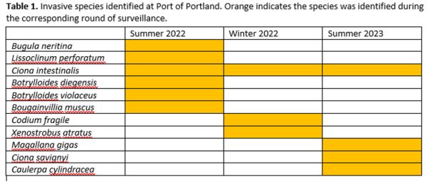
The marine program within Agriculture Victoria works closely with stakeholders including, Parks Victoria, Victorian Fisheries Authority, Environment Protection Authority, Port Authorities, Marinas, community groups and land managers responsible of marine and coastal management in Victoria to prevent and contain known areas of marine pests e.g., Undaria in Port Phillip Bay, Port of Portland and port of Apollo Bay and the Northern Pacific Sea Star in areas of south-eastern Victoria.
Exotic National Priority Pests
The following species are the major focus of the Victorian marine pest program:
- Asian Green Mussel
- Black Striped False Mussel
- Brown Mussel
- Charru Mussel
- Chinese Mitten Crab
- Harris Mud Crab
- New Zealand Green Lipped Mussel
- Asian Paddle Crab
- Didemnum vexillum (carpet sea squirt) – recently detected in WA & NSW
Ryan pointed out that Victoria is a key risk in terms of suitability for the spread of Didemnum vexillum.
Pathways of marine pest introduction
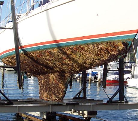
Biofouling
Biofouling occurs when organisms attach and grow on the submerged parts of a vessel such as the hull, propellors, anchors and within niche areas such as water intakes.
Ballast water
Ballast water consists of water that is taken on board a ship for the enhancement of the ship's stability at sea. Ballast water may contain sediment if it is taken on whilst the ship is in shallow or turbid water. These sediments and the water can contain a wide range of live marine and estuarine organisms. These are then transported away from their original source and discharged as the ship prepares to be loaded with cargo. The larvae and spores of invasive marine species can survive in the ballast water and colonise areas where discharge occurs.
Ryan highlighted that the Australian Federal Government regulates biofouling and ballast water management for international vessels arriving into Australian waters.
Port of Melbourne vessel entries in 2018
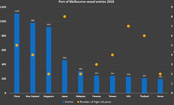
Ryan pointed out that over 4,000 vessels enter Victoria annually at the Ports of Portland, Geelong, Melbourne and Hastings. There is also a forecast of a significant increase in Global shipping into the future.
Use of eDNA in monitoring for marine pests
Ryan spoke about the transition from conventional visual monitoring and sample collection to more advanced techniques using eDNA to detect marine pests.
Agriculture Victoria engages with dive clubs and other community groups and agencies involved in the management of marine environments. The conventional surveillance techniques for marine pests include diving, shore based visual surveillance, trapping and more recently remotely operated underwater vehicles.
The adaption of eDNA technologies has proven to be more efficient and effective in monitoring programs. All organisms leave fragments of their DNA in the environment; by extracting the environmental DNA from a sample the Invasive Marine Pest Commercial Ports Surveillance Program can determine the presence of marine pests without having to observe or capture the species.
eDNA answers two key questions – What species are here and is a particular species here
Molecular surveillance program in Victoria
In Partnership with the port authorities and berth managers at the four major Victorian commercial ports, Agriculture Victoria has established a surveillance approach utilizing two sampling techniques to capture eDNA and identify marine pest species.
Settlement arrays
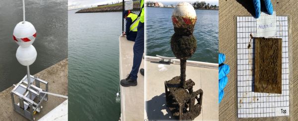
The array is lowered into the water, and moves up and down a rope anchored to the bottom of the seabed, as water height changes with tidal flow the floats on the top of the array allow it to remain just under the water.
The surveillance arrays are located at major ports: 5 arrays at Melbourne, 4 at Hastings, 2 at Geelong and 2 at Portland. Surveillance is undertaken during winter and then replicated again during summer to capture a broad range of species that are active in both cold and warmer water temperatures.
Ryan commented that each of the ports has its own environmental factors such as tides, salinity and water flow with each port showing up different growth rates and a variation in the species composition.
Water sampling
Ryan spoke about the second method of sampling which is the collection of water samples at sites where the settlement arrays are located. Between 1000-5000ml of water is drawn through a self-preserving filter using a smith and root eDNA citizen science sampler.
The collection of water samples enables the detection of non-settling organisms which may not typically be found on a settlement plate, crabs are an example of something that would not generally be picked up on the settlement plate but would be detected through environmental DNA extracted from a water sample.
Molecular analysis of samples
Agriculture Victoria have used EnviroDNA and Deakin University for the analysis of water and settlement plates. Agriculture Victoria’s AbriBio facility has now also developed capability to analyse samples.
Ryan explained that each of the eight plates from an array forms a unique sample. Thre is no pooling of plates as it has been found this can reduce the quality of information from the sampling site.
Metabarcoding
This is the primary approach undertaken for all samples, it characterises DNA barcodes from all organisms in the samples. This provides a rapid biodiversity assessment for the environment surveyed and is a good way to see what’s living within each port environment. This approach allows monitoring for a broader range of taxa (enabling screening for unlimited targets), and eliminates the need for a restricted number of targets. This also minimises the risk of missing the identification of an unexpected marine pest species.
Species specific assays
This method is targeted to look for a particular species, its more sensitive than metabarcoding. Target Based qPCR is undertaken for a highly specific and sensitive detection of one or a few target species. This approach enables rapid turnaround and simultaneous analysis of multiple samples.
Limitations
Ryan pointed out that eDNA cannot tell the sex, size, development stage or health of species detected, other monitoring techniques are required to further investigate an eDNA detection. Ongoing development of reference databases will enhance the ability to detect broader ranges of species
Port of Melbourne monitoring 2022/2023
Ryan spoke about the results of the 2023 monitoring program at Port of Melbourne.
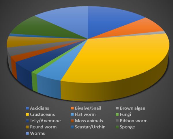
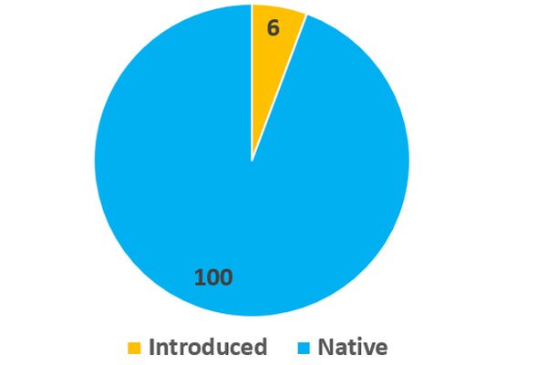
84 Taxa were identified on settlement plates in 2023 at Port of Melbourne, 54 were identified to the species level. The results are heavily dominated by crustaceans, followed by Ascidians and Flat worms.
Four potentially introduced species were detected that are known to be in the Port of Melbourne area (Asian Bag Mussel, Pacific Oyster, Stalked Sea Squirt and Skeleton Shrimp).
Seasonal changes
Ryan spoke about the need to conduct year-round surveillance as there can be seasonal variations at any given site.
Reporting
Ryan explained that each of the five ports receives an annual report summarising the outcomes of the surveillance program.
Invasive Marine Pest Commercial Ports Surveillance Program - benefits
Ryan spoke about the cost and quality efficiencies of the eDNA sampling program which is very effective in detecting pest marine organisms. Ryan also highlighted the program has enabled improved and more regular engagement with port authority staff and broader discussions regarding marine biosecurity, further developing awareness around marine invasive species. Agriculture Victoria are also working closely with managers of berths within the ports which include companies such as Graincorp, ESSO petroleum and BlueScope steel, which is also providing broader opportunities for engagement.
The early adoption of eDNA as a surveillance tool across Australian marine pest programs has demonstrated opportunities for broader adoption of this technology as a means of detecting new invasive species, quantifying biodiversity and as a way of identifying threatened species without the need for intensive surveillance programs, Agriculture Victoria is also considering this approach for the detection of aquatic state prohibited weeds within Victoria.
More information:
- Agriculture Victoria – Marine Pests in Victoria
- Agriculture Victoria – Priority Marine Pests
- Marine pest deck: Invasive species guide
Key points from questions
- Detection of eDNA works best when there is on-going depositing of DNA material into the environment.
- Arrays are placed in the water for 8 weeks to give an opportunity for organisms to attach to the plates.
- Water sampling to collect eDNA provides a rapid assessment method, particularly if there is a need to react to a report of possible marine pest incursion.
- There is scope for Citizen Science to be involved in the marine pest sampling program but a program has not yet been established.
- Reports are shared to the port managers but could be shared more widely to marine and coastal managers.
Edge AI cameras now dramatically improve monitoring capacity of Felixers
Dr John Read - Thylation
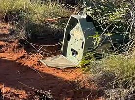
John pre-recorded his presentation from Bungala land in South Australia. He introduced his presentation by talking about Felixers, which were initially designed as a management tool to control feral cats but more recent advances in technology mean they have been developed to become an effective monitoring tool as well.
The need for a feral cat control tool
John pointed out that feral cats are the main threat to Australia’s fauna killing an estimates 1.4 billion native animals per year. Feral cats are good hunters and will not necessarily take baits or enter traps, they can be very difficult to manage and monitor. The Felixer was first developed around 15 years ago and was registered in 2023. It is designed to take advantage of the cat’s natural behaviour in grooming so that when a poison gel is fired onto the cat it will ingest the poison as it grooms itself, something that other native species and dogs don’t do. The Felixer can dramatically reduce the issue of non-target poisoning which can occur when baiting.
Felixers are fully automated, they eliminate the need to control cats using firearms or poison baits and are target specific reducing risks to native wildlife and pets. The Felixer is particularly effective in dealing with cats that are reluctant to enter traps.
John pointed out that some cats are more sensitive to new things in their environment and will avoid them but over time and with concealment of the device the cat will be less wary and the Felixer can do its job.
Felixers as a monitoring tool
John spoke about major improvements in the monitoring capability of the Felixer compared to standard passive infrared monitors. The Felixer obtains a far greater number of images of not only cats but a range of other wildlife.

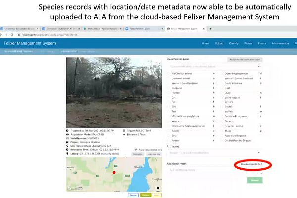
On-line cloud based Felixer Management System
The new Felixer has an on-line data base system which enables all images taken by a Felixer (regardless if the unit fires or not) to be stored along with the metadata which can be automatically uploaded to the Atlas of Living Australia. This enables a new flow of data which can be used to monitor the range and abundance of species.
Improved monitoring capacity of Felixer
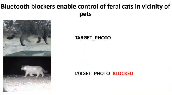
John described some of the new innovative features of the latest version of the Felixer which includes a Bluetooth antenna, GPS, and EDGE AI camera. The Bluetooth can be configured to block firing if an animal is wearing a Bluetooth tagged collar.
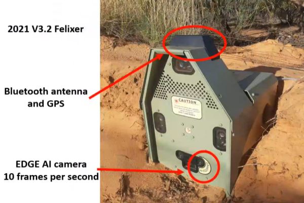
John highlighted the improved capacity of the EDGE AI cameras to detect cats whilst at the same time reduce firing gel on non-target species. With artificial intelligence and machine learning the cameras can become extremely reliable in differentiating between species which has enabled false targeting of species to be eliminated.
The units can be deployed to create a mesh and configured so that any one of the units can be connected via 4G or in remote areas Starlink which enables the EDGE AI images to be collated, thus submitting only relevant images and avoid having to sort through all images at a later date.
John spoke about some of the successful trials of using the new Felixers for fox control at selected sites where one or two foxes are known to have caused disturbance to bird breeding areas.
Bluetooth cat collars
The new Felixers with Bluetooth can be used to identify cats fitted with a Bluetooth device. This enables monitoring of problem stray cats e.g. pet cats straying into wildlife reserves. Cats fitted with a device, which could be part of a registration program would also be protected from being targeted and the offending cat identified enabling follow up with the registered owner.
Felixer use in Australia
Felixers are registered for use in all states of Australia except for Victoria. The reason for this appears to be around the use of 10:80 poison for cats, although 10:80 poison is readily used for foxes and is more liberally placed throughout the environment whereas the Felixer delivers a targeted dose to the feral cat with no impact to non-target species.
Conclusion
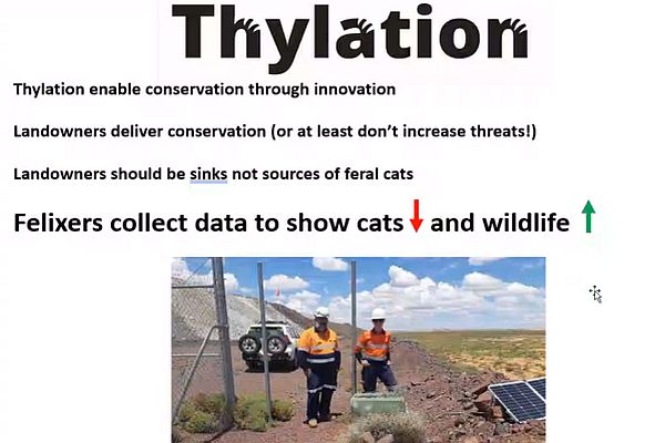
John highlighted the important role of land managers in avoiding the creation of feral cat habitat e.g., rubbish dumps and pointed out that Felixers on their own can’t eradicate feral cats but it is the responsibility of land managers to ensure their operations do not create cat habitat. Felixers have proven to reduce feral cat numbers whilst also helping to increase populations of native wildlife.
Key points from questions
- Felixers are solar powered, the units contain 20 cartridges which automatically reload after firing. In most cases the units need to check once every two months.
- The EDGE AI camera and the software of the Felixer can be adapted to provide a wider range of applications e.g., triggering a gate or feeding tray to open or close.
- The AI works best with more training, the more images that are loaded into the software the greater improvement in recognition and task management.
- There are volunteer opportunities both in the field and in-home computer-based analysis of images.
Additional key points from further questions after the seminar - responses provided by John Read.
- How do you manage vandalism of Felixer units? Apart from one Felixer that was stolen temporarily we are not aware of vandalism issues with any Felixers. Most are set in reasonably inaccessible areas that are potentially accessed by conservation savvy individuals.
- Are the monitoring parts available as a separate product? Not yet but our intention is to produce smaller, cheaper monitoring devices with the same technology
- Is there a program function that can set the time during which the unit is active? Audiolure broadcast is timed to only occur at nights but todate all Felixers operate 24/7. Weve never encounted a driver for only controlling feral cats in certain periods, but this could be accommodated with some development
- What triggers the visual image capture if not PIR? Visual recognition via the edge AI camera
- Would there be potential for deploying some kind of reusable locator tag so that carcases can be retrieved to reduce secondary poisoning? Not really, Spraying a gel has been selected as the safest means to expose feral cats but not nontargets. Firing a small dart with a locator tag would be considerably more complex and introduce additional safety hazards. However, the data and registration reveal that secondary poisoning does not represent a significant threat to any scavengers, with the only species potentially susceptible being dingoes – although dingoes (including distinctive individuals) have coexisted with Felixers for several years
- Do you run AI/Image recognition on the visual image or on the LIDAR? We use the visual image for recognition
- Can the Felixer provide data and data analysis which helps to optimize their poisoning to maximise impact? Every animal detected by the Felixer and the time, temperature, lure played, location etc are recorded. These data have, and will continue to be analysed on project and overall basis to improve efficacy
- Can this tech be trained to detect insect pollinators on flowers? Potentially, but that would involve use of different macro lenses. and probably smaller units, especially if the flowers of interest are elevated
- How much does a Felixer with AI camera cost? Felixer lease availability and costs are available by contacting www.thylation.com
More information
Hollows and how to find them
Ellen Rochelmeyer - Charles Darwin University
Ellen acknowledged the Larrakia people as the Traditional Owners of the land on which she lives and where her PhD research was conducted, she paid her respects to the Elders past and present.
Tree hollows are a critical habitat for many native fauna. There is a need to know more about the factors which influence the formation and abundance of hollows in the landscape. Ellen’s research is a long-term study focusing on understanding how different fire management strategies influence hollow abundance whilst also trialling different techniques to find and predict the abundance of hollows in a landscape.
Ellen pointed out that even though her research is based in the tropics the technologies used are applicable to other areas of Australia.
Locating tree hollows
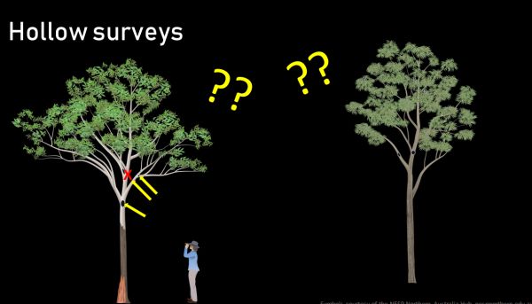
Calibrating hollow count
This task is carried out to verify how accurate visual counts from the ground are and serves as a means of obtaining a better estimate of abundance when applied to visual counts. Ellen spoke about two methods: 1. climbing trees to inspect for hollows and 2. Cut a tree down and examine for hollows.
Use of drones
Drones can be used to provide a more accurate means of conducting counts of hollows for calibration.
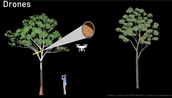
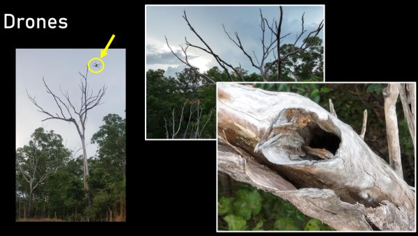
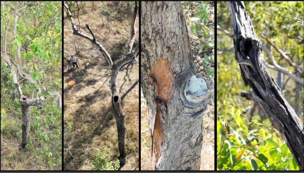
Drones enable the detection of hollows that can only be seen from above. Ellen found that many of the hollows were blocked by termite debris.
Ellen felt her ground counts were estimating an overabundance of hollows by about 9% which means any density estimates wound have to be adjusted by that much. The error rate can very depend on the environment. Ellen found that in the tropics many of the hollows were actually blocked by termite material.
How hollow is the inside of a tree
Ellen spoke about the need to work out how hollow is the inside of a tree and do branch hollows extend deep into the tree. Determining the hollowness of a tree can also have applications for Carbon accounting when estimating the amount of carbon locked in the landscape. The more hollow a tree the less carbon is stored.
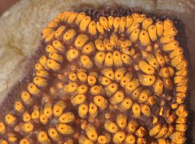
Sonic tomography
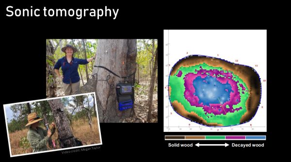
Sonic tomography is used to determine the internal structure of trees and can be used to estimate the extent of hollownes. Sensors are attached to the trunk of the tree which pick up the speed of sound passing through the tree (sound travels faster through solid wood compared to decayed wood). The equipment enables a picture to see the level of decay and hollowness inside the tree (Image right – pink and blue represent decay inside the tree, brown represents solid wood).
Ellen found that of the trees she surveyed using sonic tomography about 37% had some degree of hollowing by termites.
Remote sensing using LiDAR
Ellen used light detection and ranging technology (LiDAR) as a remote sensing tool to generate 3D image of the entire landscape in which she was working as well as the specific structure of trees. LiDAR has enabled Ellen to remotely sense vegetation structure in the landscape and potentially estimate hollow abundance. Ellen found that using a drone mounted LiDAR was very effective in covering a broad area.
Data collection apps
Ellan spoke about the efficiencies of using data collect apps to streamline data collection and entry.
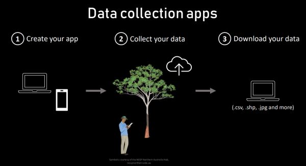
Ellen used the data collection app Fulcrum for this project.
Other data collection apps:
Key points from questions
There is potential for AI to be used in analysis of LiDAR data to estimate hollow abundance.
Due to a technical disruption the time for questions was shortened.
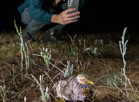
Using bioacoustics to monitor landscape-scale population dynamics of the critically endangered Plains-wanderer
Dr Aaron Grinter – Department of Energy, Environment and Climate Action (DEECA) – Loddon Malle Region, Natural Environment Program Team
Arron acknowledged the Traditional Owners and Elders of Country where the project operates, Brappa Brappa, Yorta Yorta and Dja Dja Wurrung.
Arron provided an overview of the Plains Wanderer, its conservation status, threats taxonomy and its unique behaviour in which male birds hatch eggs and raise the young.
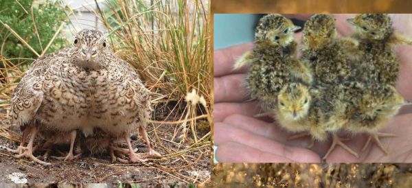
The plains Wanderer is Critically endangered at State and Federal level. It is the sole member of the Pedionomidae family, the only surviving species in a genetic line dating back 200 million years ago.
It is estimated that only about 2,000 Plains Wanders remain in the wild today.
Distribution
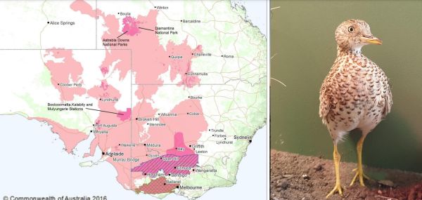
The Plains Wanderer requires a very specific habitat comprising open native grasses up to 30 cm tall with few exotic weeds and no trees around for at least 200 m. Aaron pointed out that if the habitat changes Plains Wanders will leave the area.
Threats
The main threat to the Plains Wanderer is through habitat loss which has occurred since European settlement, resulting in loss of native grasslands and conversion to agriculture. Aron pointed out than less than 1% of native grasslands still remains in Victoria, it is therefore extremely important that these are protected and well managed.
Cats and foxes are significant threats to the Plains Wanderer. Their main defence is to say perfectly still when threatened which makes them easy prey for introduced feral hunters.
Using song meters to find Plains Wanderers
Song meters provide a very good means of locating the presence of Plains Wanderers, particularly as the Plains Wanderer blends so well into the grasses and are very difficult to see.
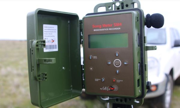
The song meters are programmed to turn on at dawn and dusk for one hour, this is when Plains Wanders call the most. Over a six-month timeframe around 300 to 400 hours of recordings are collected per unit.
Song meters provide recording of calls from which the Plains Wanderer can be identified. The Plains Wanderer call is a distinct low frequency sound which can be identified by software. Aaron spoke about the software currently being used which is Arbimon, a free, cloud-based program with unlimited data storage which is very useful as since 2017over 9 million one-minute recording have been recorded.
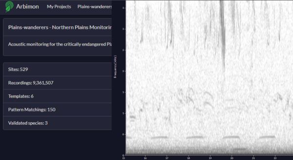
Low frequency call of the Plains Wanderer
Citizen Scientists can assist in confirming records by logging in to the Arbimon software. This has enabled some of the local community to be connected with the project.
Collation of recording data
Aaron spoke about gaining an overall picture of the Plains Wanderer records by collating all the records by date, location and frequency of occurrences. This information helps to inform the community of which locations are showing higher Plains Wanderer numbers and which areas are not.
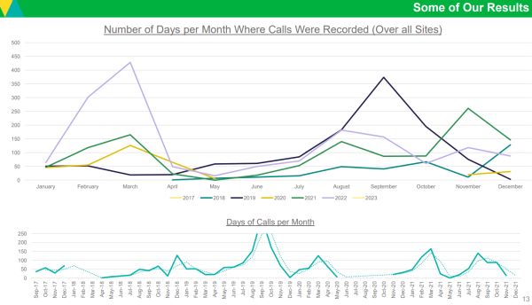
Plains Wanderer calling records across months and seasons. Upper chart; Days per month when calls recorded. Each coloured line represents a different year. There is a noticeable peak in calling late summer – early autumn and a second peak towards the start of winter. The major dip in October 2022 (mauve line) is a result of the floods which forced many of the birds out of the area but a certain number of birds were still recorded from refuge areas. After the floods the numbers of birds began to climb again.
Lower chart; Days of calls / month between September 2017 and December 2021. The Plains Wanderer is a boom-and-bust species which responds to climate and habitat quality. Aaron pointed out that the overall trend is going down.
Project partners
Aaron emphasised the project is a long-term effort to save the Plains Wanderer. The project is helping to improve the understanding of where plains wanderers occur and what their needs are. Aaron acknowledged partners involved in the project who all bring diversity an expertise to the project.

Key points from questions
There were a large number of questions - a sample provided below.
- A lot of Plains Wanderer habitat is on National Park and active agricultural land which means there has not been a program of planned burns. Aaron felt there is not enough information at present to know what the impact on this species might be if grasslands were burnt. We know that historically burns were carried out by Traditional Owners but the scale of the grasslands landscape has significantly shrunk and the number of introduced weeds would be much higher now. More work needs to be done to determine the intensity and frequency of burns to favour Plains Wanderer.
- The project is now using new Songmeter’s - SolarBAR by Frontier.
- Predation by cats and foxes is a major threat. Studies have found very positive outcomes for Plains Wanderer when fox baiting has been undertaken.
- Habitat loss is the number one issue at present – the project is working towards trying to reduce further habitat loss and protect existing habitat.
- Gaps in the distribution of Plains Wanderer across the landscape is reflective of habitat loss due to agricultural practices such as cropping.
- The major stronghold in northern Victoria is probably a result of the interconnectedness of grasslands, some small, some, large but the connection between them is important.
- The Plains Wander is an indicator species, where they occur many other native species are also found, e.g., Hooded Scaly-foot, Striped Legless Lizard, Fat-tailed Dunnart and native flora, generally species which rely on lightly disturbed grassland habitats. It is important to note that the Northern Plains Grasslands is a Critically endangered ecosystem, so by protecting the Plains Wanderer we are helping to protect the whole ecosystem.
- There has been some increase in the population since 2000 but the species is still very susceptible to a rapid decline.
- Low numbers of Plains Wanderer have been detected in the Western Grasslands Reserve. They have also been found in the Wimmera.
- There has been an expansion in weeds throughout much of the Plains Wanderer habitat since the 2022 flooding. A large weed control program will be undertaken.

Help support the Plains Wanderer - Buy a Plains Wanderer enamel pin from Bridget Farmer
More about the Plains Wanderer on SWIFFT
Notes from previous SWIFFT Seminars