Video conf. notes 27 July 2017 - Local Govt. conservation management
SWIFFT video conference notes are a summary of the video conference and not intended to be a definitive record of presentations made and issues discussed.
This video conference was supported through resources and technology provided by the Department of Environment, Land, Water and Planning, Victoria. SWIFFT wishes to thank speakers for their time and delivery of presentations. Thanks to Craig Whiteford who chaired the session from Ballarat.
The third video conference for 2017 had a theme: Local Government Conservation Management
KEY POINTS SUMMARY (Quick take home messages from this video conference or read through the speaker summaries)
Conserving our Rural Environment grant program - City of Hume
Pest Plant Local Law Education & Compliance Program - City of Whittlesea
Dandenong Ranges Stormwater Research Project 2016 - Yarra Ranges Council
Biodiversity response planning - DELWP
Conserving our Rural Environment grant program – Hannah Nicholas, Biodiversity Project Officer, Hume City Council
Overview
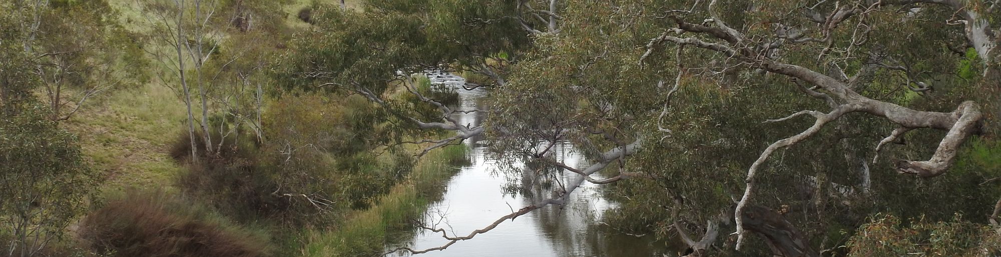
Hume City incorporates Tullamarine Airport and is bordered by the Calder Freeway on the west, Merri Creek along the east and Jacksons Creek and Kalkallo to the north. Hannah said there is about 25% of native vegetation remaining throughout the municipality most of which is classified as endangered and a majority of which is located on private property.
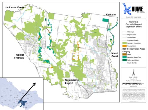
Remnant vegetation shown in light green. Growling Grass Frog habitat – dark green.
Main vegetation types on private properties
Plains Grassland - which is subject to grazing but continues to support a variety of native forbs and herbs and the endangered Golden Sun Moth and Tussock Skink. Some areas are fenced off and subject to management such as burning, crash grazing and slashing.
Plains Grassy Woodlands with large old River Red Gums and mostly modified understorey. Grazing with limited natural recruitment.
Grey Box, Yellow Box and Yellow Gum woodlands of differing age classes, size and condition. Also with recent record of Brush-tailed Phascogale.
Escarpment shrubland – found through many of the incised creek valleys supporting species like the Cunningham Skink.
Riparian Woodlands & streambank shrublands which support populations of growling grass frogs, water rats and platypus.
Threats and challenges
Hannah spoke about the main weed threats being serrated tussock, chilean needle grass, thistles and boxthorn. Emerging threats from weeds such as Cactus Wheel and Boneseed are also on the radar. Rabbits are a problem causing soil erosion in areas around Sunbury which has highly dispersive soils prone to tunnel erosion.
Because Hume is considered a core infestation of high threat weed species there is limited DEDJTR enforcement assistance. Urban interface issues, absent landholders and lack of knowledge by landholders also add to management difficulties.
Conserving our Rural Environment Program (CoRE)
Hume City commenced the CoRE program in the 2014/15 financial year. The concept was to focus on a grant program rather than a rate rebate so that the money would achieve better conservation outcomes.
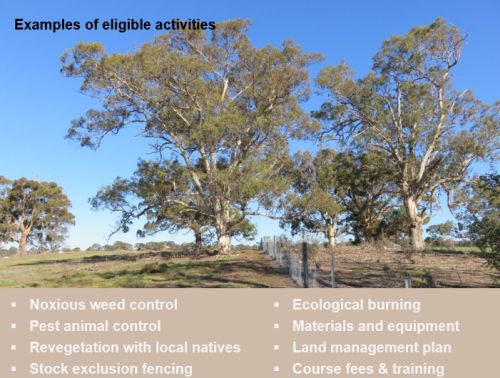
The aim of the grant is to conserve and improve rural land and the natural environmental assets on private property which is achieved through on-ground environmental works, capacity building activities and community engagement. The grant also has a strong focus on encouraging landowners to work together to implement these works.
The grant is open to all landowners that have property that is:
- Larger than 0.4ha
- Zoned as Green Wedge (GW), Green Wedge A (GWA), Rural Living Zone & Farming Zone
- Properties identified as conservation in the state’s Biodiversity Conservation Strategy
- And environmental community groups such as Landcare or Friends Groups
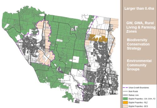
Area of eligible properties across Hume City (shown in green, yellow & buff).
How the grants work
Each financial year, landowners or environmental community groups can apply for either a small grant of $300 or a project grant of up to $10,000 to undertake a range of on-ground environment works and capacity building activities. The small grant provides landowners with general support to improve the management of their properties and is more targeted to small properties with less environmental assets.
Hanna spoke about an example of Small Grants in Sunbury which have a rabbit action group that was set up consisting of 15 different properties. Each property receives a small grant and with this funding they have combined resources to construct a rabbit proof fencing around the broader perimeter of their properties and purchase fumigation tablets.
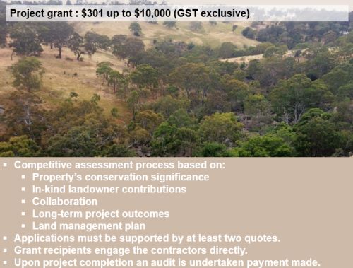
Project grants
The larger project grants provided funding of up to $10,000 and are offered as a competitive process following an EOI from a landholder. These grants involve site inspections and have strong governance arrangements that continue to be improved each year. Conserving our rural environment grant – Hume City Council
Three years of success
- 836 small grants and 80 project grants.
- In 2017/18 Hume City committed $265,000 for project grants and $70,000 for small grants of $300.
- 31 grant applications received for 2017/18.
Monitoring and review
Hanna spoke about the need to find out if the program is making a difference over time. So rather than just reporting on direct outcomes like ha of weed control and km of fencing the CoRE monitoring program is designed gather data on project outcomes over time. The monitoring program replicates the monitoring program on conservation reserves. It uses a rapid-fire habitat hectare type vegetation assessment that is undertaken by consultants.
Case studies
Hanna spoke about three case studies;
A 40 ha cattle grazing property; located on the confluence of Emu Creek and Deep Creek comprising Escarpment Shrubland with many hollow bearing eucalypts. Main activities include weed control, revegetation, exclusion fencing and fauna surveys which revealed 6 species of microbats, 26 species of birds, 1 reptile and two frog species.
A large 80 ha grazing property at McGregor Rd, Sunbury – funded to undertake training in natural sequence farming at Tarwyn Park NSW which was put into practice on the property by fencing off and revegetating creek lines to decrease the amount of erosion. In addition, over 2km of revegetation works across the property has been completed plus a 2 ha section of the best area of plains grassland fenced off. Next year it is planned that an additional 8.5 ha be fenced and revegetated with an open grassy woodland overstorey.
10ha Wurundjeri conservation reserve; located on the Victoria Volcanic Plains in Sunbury with Jacksons Creek almost bordering the eastern edge of the property. The site supports significant cultural heritage values as well as Plains Grassy Woodland with the threatened Melbourne Yellow Gums, many of which contain hollows. The CoRE program funded a conservation management plan for the property to set out 5 years of management objectives and actions. The focus of week works has been on control of galenia and serrated tussock. Wurundjeri have applied to undertake cultural ecological burning practices for the next round of funding.
Community engagement and capacity building programs
The program now includes signs for people who have participated in the program to hang on their farm gates. There was also a celebration and dinner at the local town hall with about 55 landowners attending, some talking about their experiences with the program.
The program also includes Agricultural Chemical User Permit training, field days, workshops and training on how to improve grazing management with native grasses and tours of properties demonstrating positive conservation outcomes.
Future planning
A Northwest Ecological Connectivity Investigation is currently looking at modelling connectivity within Hume and surrounding municipalities taking into account a suit of different shorter and longer dispersing species and identified linkages through the landscape. The results from this work will be built into future planning and funding.
A fauna monitoring program using baited remote sensing cameras will be undertaken on private properties. This provides a means of engaging with landholders, getting people to think about nature as well as collecting data on fauna.
Planning is underway to develop a nest box monitoring program for Sugar Gliders and Brush-tailed Phascogales along Jacksons Creek.
Key points from questions
- Funding is mainly through Council rates by turning the rebate program into a funding program.
- The majority of program involves older established landholders but some young families as well.
- Other workshops have included managing native grasslands, and developing land management plans on properties. Training topics are determined from landholder responses when filling out grant application forms.
- Officers from Hume City said they can assist other LGA’s in developing a similar program.
- Applications are limited to one grant per property per financial year. About 60% of applications are from properties who have had previous grants.
- Water monitoring in riparian areas which have been revegetated would be a good thing to do.
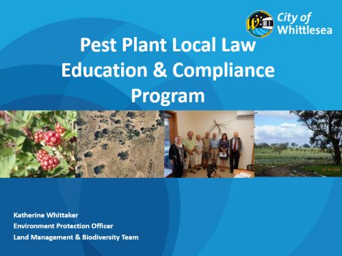
Pest Plant Local Law Education & Compliance Program - Katherine Whittaker, Environment Protection Officer, Land Management & Biodiversity Team, City of Whittlesea
The City of Whittlesea covers about 500 sq. km. The southern half of the municipality is experiencing rapid expansion and urbanisation whilst the northern part is mainly rural with a management focus on preserving agricultural and regional biodiversity assets.
Development of the program
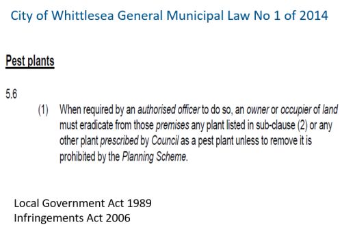
Katherine spoke about some of the steps taken in development of the current plan which commenced in 1992 via a Local Conservation Strategy (1992) which made a recommendation to approach State Government for resources to tackle significant weed issues. This was backed up by active community lobbying. In 1999 the Council nominated 8 pest plant species as a schedule to an existing Pest Plant Local Law (Artichoke Thistle, Blackberry, Chilean Needle Grass, Gorse, Pattersons Curse, Scotch Thistle, Serrated Tussock and Sweet Briar). A revised Local Conservation Strategy (2000) recommended the development of an education and compliance program to implement the Pest Plant Local Law.
In 2010 the first Environment Protection Officer role was appointed. In 2017 the program is fully resourced and being implemented.
Implementation
Local law implementation is via an authorized officer who can give direction to an owner or occupier of land to eradicate weeds (rather than control or manage). The local law is in accordance with the Local Government Act 1989 and infringements issued in accordance with the Infringements Act 2006.
In 2014 an additional 4 weed species were added to the original 8 species. A pro-active approach is taken for 3 main species with the remaining species subject to response actions. There is no compliance duplication for State Government weed programs such as Serrated Tussock.
List of weed species under Whittlesea Pest Plant Local Law
- Artichoke Thistle
- Blackberry
- Chilean Needle-grass
- Gorse
- Patterson’s Curse
- Ragwort
- Scotch Thistle
- Serrated Tussock
- Spear Thistle
- St Johns wort
- Sweet Briar
- Variegated Thistle
City of Whittlesea weeds & pest plants
Education & awareness
Education is the main part of the Pest Plant Local Law Education & Compliance Program. The Council has a local rural newsletter which is circulated to about 1000 rural landholders in which articles on pest plants, management and compliance is included. There is also a land management and biodiversity blog which provides information to residents on land management issues. Local focus group meetings and training sessions are also held.
Whittlesea Land Management and Biodiversity Blog
Pest plant local law compliance procedure
The program follows standard Local Law enforcement procedures and is managed end-to-end within the Land Management team. The Local Laws department provides support regarding legal advice but are otherwise no longer involved in the program.
The first step in the compliance procedure is serving a notice to comply. Direction is given to eradicate the particular species within 14 days to comply. Extensions are granted but timing is important, particularly when other people are controlling at the same time.
The actual infringement is issued if no work is undertaken or works deemed unsatisfactory. A small number of properties never engage in the process and factor a fine into their costs. Residents can appeal the issue of infringement
Council Incentive Programs
These programs are carried out in conjunction with and is supported by Councils other sustainable land management incentives to provide a more whole of sustainable land management approach for residents.
- Sustainable land management rebate scheme
- Environmental works grant
- Roadside weed management program
- Stream frontage management program
Key points from questions
- Managing municipal boundary interface is mainly an issue regarding waterways which requires input from Melbourne Water officers.
- It is difficult to make comparisons over time regarding the change in weeds across the municipality because the program has only been operating fully funded for a relatively short time but it is the intention to map change over time into the future.
- Melbourne water manages the Yan Yean Reservoir area.
- Issue of an infringement notices is a last resort – the program has a strong emphasis on education and getting works done.
- Katherine felt implementation of the program has been easier and more effective over the past two years as residents become more aware and better understand the reasons behind weed control.
- Uptake of a similar program in other Councils could benefit from the learnings at Whittlesea City.
- There is no overlap or duplication of the statewide Serrated Tussock program.
- It is possible to seek larger fines via the Magistrates Court for landholders who are recidivous offenders in relation to controlling weeds on their property. There is also an option of undertaking necessary works and sending the bill to the landholder.
Burrowing Cray on a bed of clay, with crushed Amphipod and Slender Tree Fern - Marty White, Executive Officer, Biodiversity Conservation, Yarra Ranges Council.
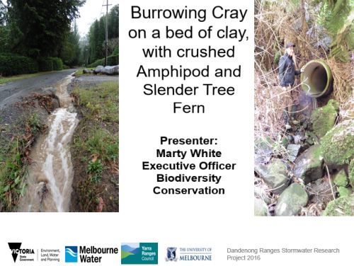
This project is the Dandenong Ranges Stormwater Research Project 2016, funded through DELWP, Melbourne Water with support from Melbourne University.
The project area is located in the headwaters of the upper catchments of Woori Yallock, Olinda and Monbulk Creek in the Dandenong Ranges. Streams these headwaters contain high value waterways and threatened species. They are significant contributors to the Yarra River and Dandenong Creek catchments.
The two main threats to the upper catchments come from storm water and environmental weeds.
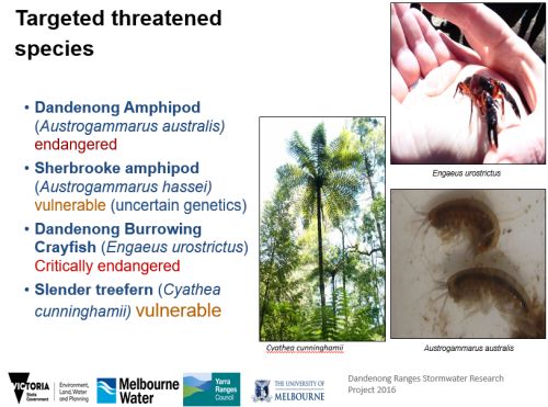
Marty spoke about targeted threatened species and their association with high quality water. Surveys have been carried out on target species to improve knowledge as these species have not been extensively studied.
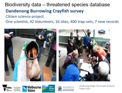
Burrowing Cray
Marty said it is difficult to survey the burrowing cray as they only surface for reproduction during cooler wet months. The survey was a Citizen science project lead by Di Crowther from Arthur Rylah Institute and with 40 volunteers. Results include 7 new records at 6 sites which almost doubled the known records which is quite significant.
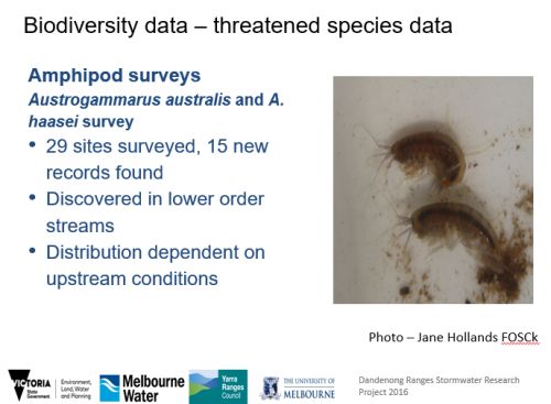
Dandenong and Sherbrook amphipods
The Dandenong and Sherbrook amphipods are indicators of good water quality as they required unpolluted and undisturbed leaf litter. Surveys by external consultants found 15 records between the two species over 29 sites. 11 sites had not previously been surveyed. These findings reinforce the importance to protect these pristine creeks from increasingly polluted stormwater flows.
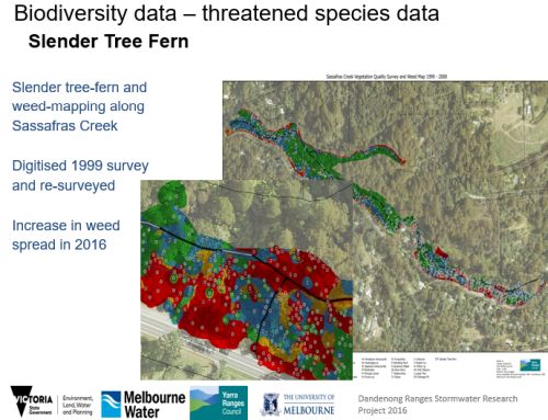
Slender treefern
Slender treeferns are under threat from weed infestation of riparian habitat facilitated by stormwater as well as bank erosion downstream from outfalls which has been observed causing other treeferns to collapse.
Vegetation and weed mapping was as well as slender tree fern mapping was undertaken on a section of Sassafras creek. These were compared to a previous study by the same consultant in 1999 and there was noticeable increase in weed spread.
Victorian Biodiversity Atlas species locations and identified outfall areas have been mapped using GIS to enable more efficient on-going management.
Stormwater impacts on waterway ecosystems
Marty discussed the impact of urban development on water flows. He spoke about pre-urban development hydrographs (water flow over time) which demonstrate under a storm event a slow rise of water to a peak flow then dropping back indicating a large amount of rainwater is going into vegetated areas and groundwater. The urban scenario is quite different with flash flood high flow events which increases;
- sediment transportation
- higher nutrient loads
- gully erosion
Stormwater flows are a key threatening process for sensitive in-stream and riparian species.
Marty spoke about the need to the need to move into a proactive approach with strategy and prioritisation to ensure investment into sites that will have the best outcome for reducing stormwater flow impacts into streams. He said the current project liaised with the Waterway Ecosystem Research Group (WERG), Melbourne Uni in how to lead an innovate best practice project in stormwater research.
Prioritising water sensitive urban design (WSUD) projects at highest risk stormwater outfalls in the Dandenongs
- Identify major stormwater outfalls and their impact on receiving waters.
- Prioritise Water Sensitive Urban Design (WSUD) works to mitigate impacts and develop an area-specific stormwater management.
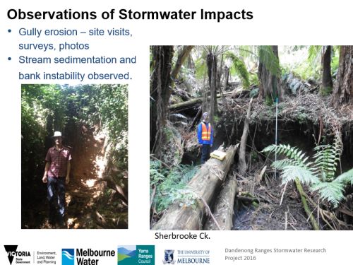
Examples of impacts of outfall resulting in erosion.
Prioritizing management works
Marty spoke about mapping natural and engineered catchment data in maps. He used the term Effective Imperviousness (EI) the amount of impervious (hard surface) that delivers storm water to a stream system. The % of EI in a system is the dominant driver for the health of stream ecology.
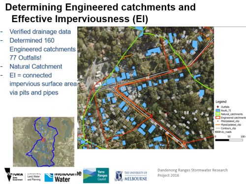
Mapping engineered catchments (the blue areas represent roofs, red areas combined with other hard surfaces and pipes) used to model flows and scenarios for improved outflows to creeks.
‘The most likely dominant process degrading macroinvertebrates instreams can be reversed by preventing increased frequency of surface runoff generated by EI during small to moderate storms’ (Walsh, 2005). Chris Walsh at Melbourne University has found that where there is more than 2% EI there is a significant drop in a number of ecological indicators in sensitive macroinvertebrates.
Analysis of the top 16 outlets
This work was strategically selected based on:
- EI score.
- Proximity to waterway.
- Threatened species present
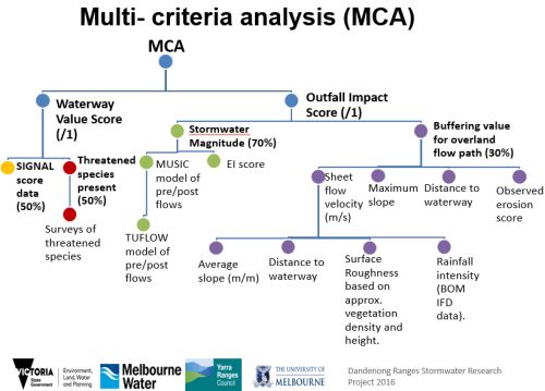
Marty spoke about multi criteria analysis (MCA) which essentially looks at assigning a score to waterway values and outlet impact. The outlets were prioritised in order with 9 outfalls investigated for treatment constraints. The top three problem outfalls were (Sassafras township, 533 Mt Dandenong Tourist Road, Olinda and Kallista roundabout 2). The data analysis from this project validates the choice of Sassafras township as the stormwater outfall with the highest risk in the Dandenong Ranges which has already resulted in engineering changes.
Recommendations
- Invest in Water Sensitive Urban Design (WSUD) projects in high-value upper catchments.
- Capitalize on threatened species data to leverage funding and community interest.
- Exhaust data already available. Engage with local friends groups and Universities early on to broaden historical and current catchment knowledge.
- Devote more time into GIS work for catchment analysis, it’s a powerful tool!
- What is ideal (prioritised) isn’t always practical, other factors can overrule what is achievable.
- Engage and request feedback from relevant stakeholders when finalising an MCA.
- MCA à Risk matrix àIdentify high-risk à Treatment constraints àHydrological Modelling à CBA à Concept design.
Marty thanked the people and organisations involved in the project.
References:
Stream restoration in urban catchments through redesigning stormwater systems: looking to the catchment to save the stream (2005). Author(s): Christopher J. Walsh, Tim D. Fletcher, Anthony R. Ladson. Source: Journal of the North American Benthological Society, 24(3):690-705. Published By: The Society for Freshwater Science. DOI: http://dx.doi.org/10.1899/04-020.1 ; http://www.bioone.org/doi/full/10.1899/04-020.1
Key points from questions
- The use of Multi Criteria Analysis in prioritising water sensitive urban design could be replicated for a range of catchments but may require some localised modification.
- Further studies will be undertaken to look at habitat requirements for the burrowing cray.
- It is important to focus on priority outfalls to reduce erosion and impacts on stormwater. Issues for Councils and VicRoads involves the bituminising of roads which requires formal drainage and design.
- The costs of having to undertake engineering rectifications to resolve outfall issues are generally much greater afterwards rather than being considered in the design stage.
- Community groups have been a large driver for getting action on the erosion impact of outfalls in the Dandenongs and the impacts on threatened species. Further work to improve community engagement and citizen science into waterways will be undertaken.
Biodiversity response planning – Adam Muir, Department of Environment, Land, Water and Planning
Adam introduced the topic by talking about the vision and two equal goals in the new Biodiversity Plan 2017;
- Goal 1. Victorians value nature
- Goal 2. Victoria’s natural environment is healthy
For the next year or two Biodiversity response planning will focus on the goal ‘Ensuring Victoria’s natural environment is healthy‘ but over time the other goal will be included as well.
Biodiversity response planning will enable more and better collaborative arrangements, developing a shared vision and working together. Adam explained it is a new approach because it:
- considers all environments, using statewide and local information
- considers all land tenures - also has biodiversity as its sole focus and is inclusive of interests and stakeholders
Biodiversity Response Planning
Adam spoke about the need for more and better collaborative arrangements for to achieve goals in the Biodiversity Plan. He emphasised the intention to include all interested parties so they can be involved in the process.
- The process will allow for everyone to come together and collaboratively plan on-ground projects within an area.
- Landscape or area-based “biodiversity forums” will be established. (Areas are not yet defined)
- Participants include: State and Local government agencies, public land managers, Traditional Owners, community groups, NGOs, business and industry, etc.
- Projects developed out of this process will be considered for state biodiversity investment (e.g. $20 million/year ongoing to implement the Biodiversity Plan)
- The process also enables government and non-government organisations to “pledge” their contribution to statewide biodiversity targets for next 5 years including a non-binding, but public statement of intent.
- Documenting Five-yearly “pledges” as well as an annually updated biodiversity project schedule so everyone knows what projects are going on will be a key input into the development of an overall Biodiversity Investment Prospectus.
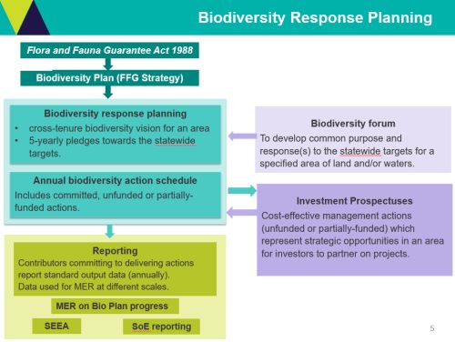
Biodiversity Response Planning Process Source: Protecting Victoria’s Environment - Biodiversity 2037.
Adam emphasised the 5-year cycle in terms of reviewing the vision and pledges but also an annual cycle of refreshing projects. Another important aspect is the Statewide Investment Prospectus which documents unfunded or partly funded projects which represent good value for money. Documenting projects, outcomes & partners will provide valuable information to prospective investors. Adam also spoke about the need for consistent reporting across local and regional Victoria to measure progress towards targets in the Biodiversity Plan.
Stakeholder workshops
Adam spoke about workshops to be held over next few months with the intent to co-design a model of Biodiversity Response Planning, including:
- What geographic areas make sense for biodiversity planning?
- How do we work together in a sustained meaningful way (collaboration, shared vision)?
- Who should be at the table (participation, engagement)?
- How can people participate (what processes work best, where do we need to build capacity)?
- What are the current processes that are working really well which could be used?
- What the “biodiversity forums” should look like and how should they operate (areas, roles, process)?
- What roles should government and non-government organisations play going forward?
It is intended the process of much improved collaborative planning (Biodiversity Response Planning) will commence in early 2018 through 2019 for the investment cycle onwards.
A new way of approaching on-ground action
Adam explained there needs to be a shift to a “system stewardship” role that creates an enabling environment for community and stakeholders to participate and make decisions which cause a collective impact. When resources are scarce the temptation is to compete, but the need is to collaborate in order to exert collective impact towards achieving outcomes.
Another new concept will be to establish a Monitoring Evaluation Reporting (MER) framework and practice that can capture the efforts at the local scale so that all partners and stakeholders are appropriately acknowledged for their contributions to the goals targets of the statewide biodiversity plan.
Adam reinforced the intent of increased collaboration but acknowledged it is not easy and will require all of us to reflect on what we need to do differently to meet this challenge. He posed the question; What could you or your organisation do to help?
Biodiversity Plan – Biodiversity 2037
e-newsletter updates – sign up
Key points from questions
- It is envisaged that there could be 10 to 15 regional scale biodiversity forums but as the process is undertaken it may turn out that as well as regional scale workshops there may need to be some smaller local scale workshops.
- Parks Victoria along with all other relevant organisations will be part of the process. Funding directed to projects could flow through to Parks Victoria or anyone best positioned to deliver outcomes. Some projects will be large landscape type projects whilst others could be very specific to an area or population of threatened species requiring management.
- The Education Department is included in the process.
- The Biodiversity Plan team is open to looking at examples from other sectors in relation to building on proven methods for collaboration and project planning methodologies.
- The use of marketing and promoting biodiversity was raised and acknowledged as being important but the focus at this time is directed to on-ground biodiversity activities due to a limited budget.
- Biodiversity Team is working across all parts of DELWP to ensure land, water and fire management is involved in the Biodiversity Response Planning process.
- SWIFFT can play a role in the communication/collaboration process through video conferences, web site and established contacts.
KEY POINTS SUMMARY
| The Hume City, ‘Conserving our Rural Environment Program’ (CoRE) focuses on grants rather than a rate rebate to achieves better conservation outcomes. |
| In the past 3 years there have been 836 small grants and 80 project grants to undertake a range of on-ground environment works across Hume City. |
| The City of Whittlesea operates an effective ‘Pest Plant Local Law Education & Compliance Program’ which also includes an ‘education & awareness program’ to help landholders control weeds and protect biodiversity values. |
| Two main threats to the Dandenong’s upper catchments come from stormwater and environmental weeds. Stormwater flows are a key threatening process for sensitive in-stream and riparian species. |
| Effective Imperviousness (EI) is the amount of impervious (hard surface) that delivers storm water to a stream system. The % of EI in a system is the dominant driver for the health of stream ecology. |
| Biodiversity Response Planning is part of Victoria’s new Biodiversity Plan and will enable more and better collaborative arrangements, developing a shared vision and working together. |
SWIFFT extends thanks to Hannah Nicholas (Hume City), Katherine Whittaker (City of Whittlesea), Marty White (Yarra Ranges Council) and Adam Muir (DELWP) for their very informative presentations.