Turnip Copperbur
Turnip CopperburrSclerolaena napiformis | |
|---|---|
| Kingdom: | Plantae |
| Division: | Magnoliophyta |
| Class: | Magnoliopsida |
| Order: | Caryophyllales |
| Family: | Chenopodiaceae |
| Status | |
| Australia: | Endangered EPBC Act |
| Victoria: | Criticaly Endangered (DELWP 2020) |
| FFG: | Listed, Action Statement No. 171 |
Turnip Copperburr is one of the Chenopodiaceae or saltbush family of plants and one of 7 species of Sclerolaena listed as thretened in Victoria as part of a re-assessment of threatened flora in 2020. Previously known as Turnip Bassia the Turnip Copperburr gets its common name from the copper coloured hard spiny fruit.
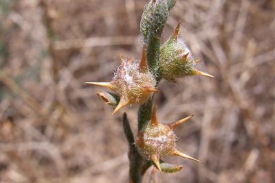
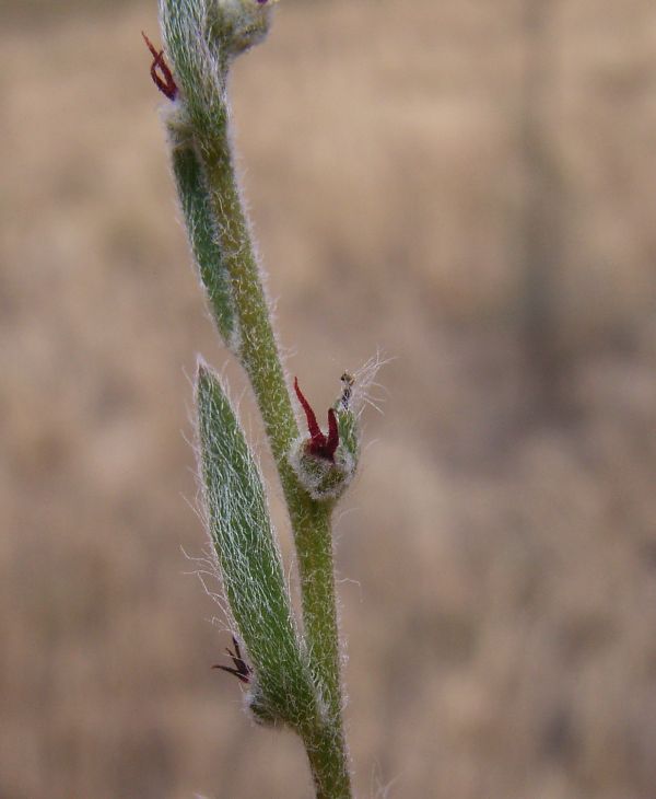
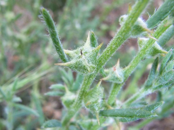
The Turnip Copperburr is described as an erect perennial growing to 30 cm tall with multiple branches sparsely covered with small hairs. Leaves are sparse, blue-green in colour 10-15mm in length x 4mm wide with hairs. Singular flowers to 3mm are located at the base of the leaf axils. The fruiting perianth is turnip shaped (reflected in both common and Latin name) green and woody with hairs and 5 or 6 spines, usually 4 long spines (2.5-4mm) and 2 minor spines (1mm), the fruit attains a copper colour when mature (Wilson 1984, Walsh & Entwisle 1994, DSE 2009).
Distribution
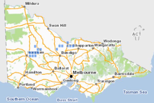
All known records of Turnip Copperburr in Victoria. Source: VBA 2019.
Turnip Copperburr is distributed throughout the Riverina areas of northern Victoria and southern New South Wales and also the Wimmera area in Victoria’s South West region where it mostly occurs in the Rupanyup North, Marnoo and Avon Plains areas. Victoria is the stronghold of this species. The Victorian population was estimated to be less than 23,000 plants with less than 1000 plants remaining in the wild in NSW (DSE 2009). Surviving plants are mainly restricted to a few small uncultivated areas on private land, isolated reserves and roadside areas which have remained reasonably intact from soil disturbance” due to cropping, ploughing and overgrazing.
Ecology & Habitat
Turnip Copperburr is found on fertile red clay loam plains in association with native grasslands or Box/Buloke woodland where it colonises small bare areas, sometimes in wet conditions. Flowering and production of fruit normally occurs in summer to autumn, by late autumn plants die back to their tap root and re-sprout again in spring.
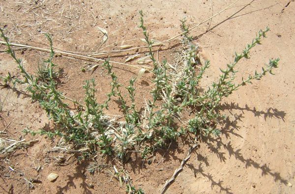
Turnip Copperburr plant. Image: Ben Thomas
Flower buds appear after 21 weeks from germination and can mature by week 29. Life span is unknown but has been observed beyond two years and may be similar to S. birchii and S. diacantha which have a life span of one to three years (Carta & Parsons 2005).
Seeds only germinate after the woody fruit has broken down which means seed can remain dormant for at least two years. Germination can occur in any season provided there is sufficient rainfall.
Ants
Associations between seed harvesting ants and some species of Sclerolaena have been noted where ants (Rhytidoponera species B and Monomorium whitei) have been observed to collect fruits which are taken back to nests where seeds are taken out from the woody fruit and stored. This may assist distribution and placement of seeds to aid germination at a later date when conditions are favourable.
Fire
Relationships between burning and Turnip Copperburr are not fully understood and it is not clear if burning is advantageous or a threat to this species. Burning may be detrimental as Chenopods have been observed to have generally low sprouting proportions after clipping and extremely low sprouting following burning (Vesk et al. 2004).
A general observation of a population near Marnoo in Victoria showed good growth after a burn, though no formal surveys have been undertaken on the species response to fire (M. Thorpe pers. comm. 2019).
More work is required to determine the positive or negative relationships with fire which could be influenced by the site conditions, intensity and timing of burning.
Population Status
In 2002 the total abundance in the wild in Victoria was estimated to be less than 7 500 (Alexander 2002). With more intensive surveys over several years the Victorian population was revised to less than 23,000 plants in approximately 23 known wild populations (DSE 2009).
Many populations of Turnip Copperburr are in decline, especially along roadsides and several appear to have become extinct in recent years (DSE 2009).
Threats
Any reduction in site security at remaining sites poses a threat, particularly where the use of machinery is involved as this could result in physical disturbance, loss of plants and susceptibility to weed invasion. Practices such as roadside slashing and the ploughing of firebreaks are therefore particularly undesirable. Inappropriate tree planting may also be a problem where existing habitats need to be retained. Repeated exposure to excessive grazing is likely to impact on the capacity of the plant to establish regrowth, flower and development of seed. It is most important to seek advice prior to carrying out any works in the vicinity of areas where Turnip Copperburr is known to exist.
Impacts from burning have not be fully explored and requires more research.
Conservation of Turnip Copperburr in Victoria
The conservation status of Turnip Copperburr was re-assessed from Endangered in 2014 (DEPI 2014) to Critically Endangered in 2020 as part of the Conservation Status Assessment Project – Victoria (DELWP 2020).
Key Local Government Areas
- Buloke Shire
- Campaspe Shire
- Northern Grampians Shire
- Yarriambiack Shire
Ensure known sites are protected in the local planning schemes.
Other recommended actions
Undertake surveys to locate additional populations.
Encourage Universities to undertake further research into the effects of competition and recruitment of Turnip Copperburr.
Involve community groups (e.g, Friends of Parks), field naturalists, volunteer’s etc. in survey, monitoring and management activities.
Locations of importance
Source: DSE 2009
- Avon Plains Swamp Nature Conservation Reserve, Avon Plains
- Creswick’s Well Wildlife Reserve, Avon Plains
- Wanurp Nature Conservation Reserve
- Private Property - Avon Plains (Shire of Buloke and Northern Grampians Shire)
- Private Property – Marnoo (Northern Grampians Shire)
- Private Property – Grays Bridge (Northern Grampians Shire)
- Echuca Aerodrome, Echuca (Shire of Campaspe)
Roadsides
- Anderson’s Road, Echuca (Campaspe Shire)
- Avon Plains Road (Northern Grampians Shire)
- Donald-Avon Plains Road, Avon Plains (Northern Grampians Shire)
- Donald-Stawell Rd, South of Donald (Buloke Shire)
- Echuca-Serpentine Road, Mitiamo (Campaspe Shire)
- McKinley Road, Avon Plains (Northern Grampians Shire)
- O’Deas Road, Koyunga (Campaspe Shire)
- Trevaskis Road, Wyuna (Campaspe Shire)
Other roadside sites requiring monitoring
- Boyle Rd, Marnoo East (Northern Grampians Shire)
- South of O’Brees Rd, Remlaw, Horsham (Rural City of Horsham)
- Longerenong Rd, East of Longerenong (Shire of Yarriambiack)
- East and southeast of the township of Banyera, near the Richardson River (Northern Grampians Shire)/ (Shire of Yarriambiack)
- Pimpinio Rd, Rupanyup (Shire of Yarriambiack)
- Raynes Rd, Grey’s Bridge (Northern Grampians Shire)
- Stawell-Warracknabeal Rd, south of Rupanyup, (Shire of Yarriambiack)
- Tennis Rd, Watchem West (Shire of Buloke)
Populations of Sclerolaena napiformis have been found at each of the following roadsides, though require surveying to identify estimated number and extent of plants in each population (M. Thorpe pers.comm 2019).
- Soldiers Rd, Marnoo
- Glenorchy Road, Rupanyup
- Bolagum Silo Road, Marnoo
- Waranooke Road, Rupanyup
- Carrs Plain Road, Marnoo west
- Banyena Silo Road, Banyena
- Hazeldene Road, Marnoo
- Gwenap Road, Marnoo
- Murtoa-Glenorchy Road, Murtoa
- Dunmunkle Creek road, Rupanyup
- Bryce Road, Marnoo East
- Raywood-Durham Ox Road east of Serpentine, Shire of Loddon
Projects & Partnerships
In March 2006 a Turnip Copperburr field day was organised entitled Recognising Roadside Remnants. This was a joint venture between DSE, the Avon Plains Landcare Group and the Donald and District Landcare Group.
The Buloke and Northern Grampians Landcare Network are also involved in the conservation of Turnip Copperburr, contact Kevin Spence Landcare Coordinator - 0408 353 966.
A considerable amount of survey work was carried out between 1999 and 2011 via DSE which helped ascertain the species key locations and status.
During the 2010-2011 season DSE staff at Horsham and International Student volunteers carried out surveys. Seven sites known for this species in the Wimmera were assessed for threats and baseline population data was collected. Sites ranged from under 50 plants to several hundred. A new population was found on Longerenong Rd and one on Burrum-Banyena Rd, both within the Yarriambiack Shire. Signage for three roadsides were organised with the Yarriambiack Shire and two populations were mapped.
Between 2016 and 2018 a number of Sclerolaena napiformis populations were identified while undertaking surveys of Pimelea spinescens spinescens as part of the Wimmera threatened species project (funded by Wimmera CMA and National Landcare Program). It was observed that both threatened species were often found growing in close proximity in the same vegetation type.
DELWP has undertaken roadside monitoring of Pimelea spinescens populations and associated grassland species including S. napiformis in the Loddon Mallee area (2018/19).
Research
In 2019, genetic studies, germination and growth trials are currently being undertaken on S. napiformis by the Royal Botanic Gardens Victoria, Cranbourne. About 150 plants make up the ex-situ collection and it is hoped this should increase to around 300 by autumn 2019.
The RBGV have also propagated S. napiformis successfully from cuttings.
References & Links
Alexander, J (2002) Flora & Fauna Guarantee Action Statement: Turnip Bassia Sclerolaena napiformis, Parks Flora Fauna Division, Department of Sustainability and Environment: Melbourne.
DSE (2009) Flora & Fauna Guarantee Action Statement: Turnip Bassia Sclerolaena napiformis, Department of Sustainability and Environment: Melbourne. Renamed - Department of Environment, Land, Water and Planning, Flora Fauna Guarantee Action Statement No.171 pdf
Carta, F.E., Parsons, R.F. (2005) Notes on the germination of the endangered species Sclerolaena napiformis (Chenopodiaceae), Cunninghamia 9(1):215-218, 2005.
DELWP (2020) Provisional re-assessments of taxa as part of the Conservation Status Assessment Project – Victoria 2020, Department of Environment Land Water and Planning, Victoria. Conservation Status Assessment Project – Victoria
DEPI (2014) Advisory List of Rare or Threatened Plants in Victoria – 2014, Victorian Department of Environment and Primary Industries, East Melbourne, Victoria. Advisory List of Rare or Threatened Plants in Victoria 2014.pdf
Thorpe, M. Pers comm. (2019) Mirinda Thorpe, Department of Environment, Land, Water and Planning, Victoria, Grampians Region, Horsham.
Vesk, P.A., Warton, D.I. & Westoby, M. (2004) Sprouting by semi-arid plants: testing a dichotomy and predictive traits, Oikos 107 (1), 72-89.
Walsh, N.G. & Entwisle, T.J. (1994) Flora of Victoria, Volume 2 - Ferns and Allied Plants, Conifers and Monocotyledons. Inkata Press, Melbourne.
VBA (2019) Victorian Biodiversity Atlas, Department of Environment, Land, Water and Planning, Victoria.
Wilson, P.G. (1984) Chenopodiaceae, Sclerolaena napiformis, In: Flora of Australia, Vol. 4 (ed) George, A.S., p.330, Australian Government Publishing Service: Canberra