Video conf. 26 July 2018 Drones (Ethics of and practical applications)
SWIFFT video conference notes are a summary of the video conference and not intended to be a definitive record of presentations made and issues discussed.
This video conference was supported through resources and technology provided by the Department of Environment, Land, Water and Planning, Victoria and Zoom. SWIFFT wishes to thank speakers for their time and delivery of presentations. Thanks to Michelle Butler who chaired the session from Ballarat.
The third video conference for 2018 had a theme: Drones – Ethics of and practical applications.
KEY POINTS SUMMARY Quick take home messages from this video conference or read through the speaker summaries.
- Drone technology and rules/ regulations governing their use (Colin Clarke)
- Potential applications of drone technology in conservation (Dr Ramesh Raja Segaran)
- Responsible/ ethical use of drones (Jarrod Hodgson)
- Case Study – Koala’s, UAVS and thermal imaging (Dr Grant Hamilton)
List of groups/organisations in attendance
Approximately 100 participants were connected across 18 locations; Ararat, Bairnsdale, Ballarat, Benalla, Bendigo, Colac, Geelong, Hamilton, Heywood, Horsham, Irymple, Heidelberg (Arthur Rylah Institute), Lonsdale Street (Melbourne), Knox (Melbourne), Orbost, Traralgon, Warrnambool and Wodonga.
A trial of Zoom video conferencing was conducted which provided a broader collaboration platform as both presenters and viewers were able to share screens (for both audio and visual material), text chat and have remote desk top control.
Educational: Federation University, University of Melbourne, Bendigo TAFE, Queensland University of Technology and University of Adelaide.
Local Government: City of Whittlesea, Yarra Ranges Shire, Brimbank City Council.
Field Naturalist Clubs: Ballarat, Bendigo, Hamilton, Portland, Geelong and Bairnsdale.
Community Conservation Groups: Birdlife Hamilton, Ballarat Environment Network, Friends of Eastern Otways, Kowree Farm Tree Group, BG Landcare, Connecting Country, Moorabool Landcare, Napoleons/Enfield Landcare, Wombat Forestcare, Wedderburn Conservation Management Network, Moorabool Landcare, Pallisters Reserve (Warrnambool), Australian Plant Society (Warrnambool), Regent Honeyeater Project.
Conservation Organisations: Waterwatch, Dolphin Research Institute, Conservation Volunteers Australia (Little Desert re-wilding), Victorian National Parks Association, Coastcare, Glenelg Hopkins CMA, West Gippsland CMA, Wimmera CMA, Parks Victoria (Orbost, Otways), Geelong Native Title, Winda-Mara Aboriginal Corporation, Victorian Volcanic Plains Biosphere, Native Fish Australia, Department of Education & Training (Koorie engagement support officer, Orbost), Department of Environment, Land, Water and Planning (DELWP) staff across 18 locations
Private individuals: x 14
SPEAKER SUMMARIES
Drone technology and rules/ regulations governing their use - Colin Clarke (DELWP).
Colin is a Senior Aviation Project Officer for the Department of Environment, Land, Water and Planning (DELWP).
Colin provided an introduction to the work that DELWP is undertaking in investigating the use of emerging technologies such as Unmanned Aerial Vehicles (UAV’s) or Remotely Piloted Aircraft Systems (RPAS) for environmental and land management research and / or operational applications.
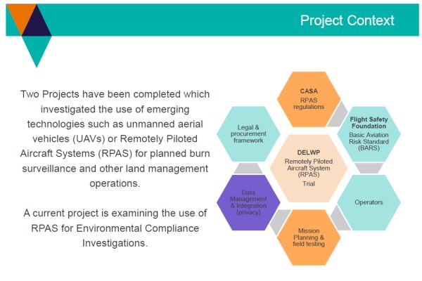
Demonstration phase
Missions were conducted by Lockheed Martin / WorleyParsons. Flights were carried out over a period of 30 operating days, at 26 sites across Victoria, with a total of 64 flight hours.
- Pre & Post burn operations (not carried out due to wet seasonal conditions and timelines for CASA approvals)
- Dam inundation mapping
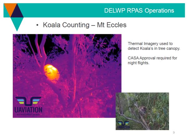
- Koala detection
- Cultural Heritage mapping
- Hazardous Tree assessment
- Whale disentanglement
- Coastal Erosion
- Wildlife exercises
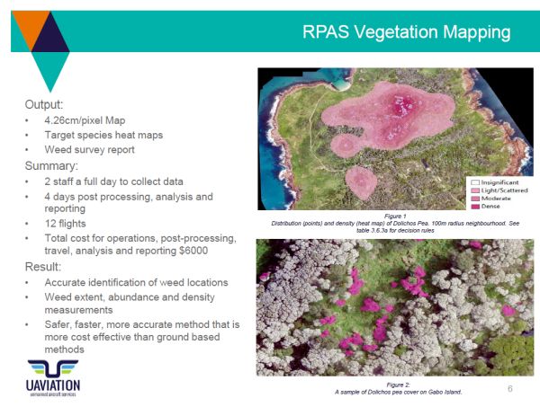
- Invasive species detection
Regulatory controls
Colin provided an overview of Civil Aviation Safety Authority (CASA) Regulations relating to the use and operation of UAV’s and RPAS.
Unless specific approval has been granted, RPAS can only legally be operated as follows:
- Daylight operations only.
- Not above 400 feet, (122 meters);
- Not over a populated area;
- Not within 3.5nm of an airport and;
- Not beyond VLOS
Victorian National Parks Regulations, 2013, 102 Using aircraft prohibited
(1) A person must not, in a park—
(a) launch or land an aircraft; or
(b) deliver anything by an aircraft.
Penalty: 20 penalty units
Paragraph (2) presents the opportunity to apply for a permit from PV. These are only available to commercial RPAS operators with Operator’s
Certificate issued by CASA.
Panel of providers
DELWP have established two RPAS Panel of Providers, consisting of six companies with a wide variety of capabilities. The panel provides access to at least 28 different types of RPAS (Fixed wing and multi-copter).
Some of the capabilities of the panel include:
- 4K and 8K video
- High resolution image capture
- Multi-spectral and Hyper-spectral
- Thermal/Infra-red imagery
- LiDAR
- Orthomosaic imagery
- Extended flight times of beyond four hours
The providers are all Civil Aviation Safety Authority (CASA) accredited and meet DELWP safety requirements.
Potential applications of drone technology in conservation - Dr Ramesh Raja Segaran, University of Adelaide
Ramesh is a Postdoctoral Researcher within the Ecology and Environmental Science faculty of the University of Adelaide.
Ramesh provided an overview of his research interests and some of the work he has conducted at the University of Adelaide, particularly with respect to the use of unmanned aerial vehicles or Remotely Piloted Aircraft Systems for environmental management and precision agriculture, spatially explicit decision support systems and spatial analyses and modelling.
Responsible/ ethical use of drones - Jarrod Hodgson, University of Adelaide
Jarrod is an ecologist and PhD candidate at the University of Adelaide.
Jarrod provided an overview of his research around best practice for minimising unmanned aerial vehicle disturbance to wildlife in biological field research. Jarrod’s previous publication in Current Biology 26, R387–R407, May 23, 2016 (see attached below) formed the basis for much of the presentation.
Key points
- Adopt the precautionary principle in lieu of evidence regarding decisions about minimum wildlife disturbance and flight practices.
- Utilise the institutional animal ethics process to provide oversight to UAV-derived animal observations and experiments.
- Adhere to relevant civil aviation rules and adopt equipment maintenance and operator training schedules.
- Select appropriate UAV and sensor equipment. UAVs should be selected to minimise visual and audio stimulus to wildlife.
- Exercise minimum wildlife disturbance flight practices.
- Cease UAV operations if they are excessively disruptive.
- Provide detailed, accurate reporting of methods and results in publications.
Case Study – Koala’s, UAVS and thermal imaging.- Dr Grant Hamilton, Queensland University of Technology (QUT)
Dr Grant Hamilton is the Senior Lecturer in Ecology (Biosecurity) of the Science and Engineering Faculty at the Queensland University of Technology (QUT).
Grant provided an overview of the work that he is leading for QUT on the deployment of drones that can capture high resolution imagery to allow for rapid estimates of koala abundance in a high-tech effort to find and protect koalas in South East Queensland.
Further information on this project: https://www.qut.edu.au/news?news-id=120417
Group discussion
This session resulted in sharing of further information
Both, the University of Adelaide and the Queensland University of Technology are currently undertaking research projects utilising new and emerging UAVs and RPAS technologies and should be contacted directly for any specific information about their research projects.
KEY POINTS SUMMARY
| DELWP has used (UAV’s and RPAS) for vegetation mapping, coastal monitoring (photogrammetry and topographic LiDAR), duck season monitoring and koala counting (thermal imagery). |
| The Civil Aviation Safety Authority (CASA) as well as Parks Victoria has strict legislative controls for use of (UAV’s and RPAS). Summary |
| The use of new UAVs and RPAS technology could have undesirable and unforeseen impacts on wildlife, the risks of which we currently have little understanding. |
| In the absence of any formally recognised Code of Practice or Guidelines around the use of UAVs and RPAS technology near wildlife, the precautionary principle to manage these risks is recommended. |